
THE ROOST'
USGS Mount Triumph 7.5'
July 12, 1966
Written 1985
Party: John Roper and Taffy
My First First Ascent
The Roost
from north, near Glees Knee
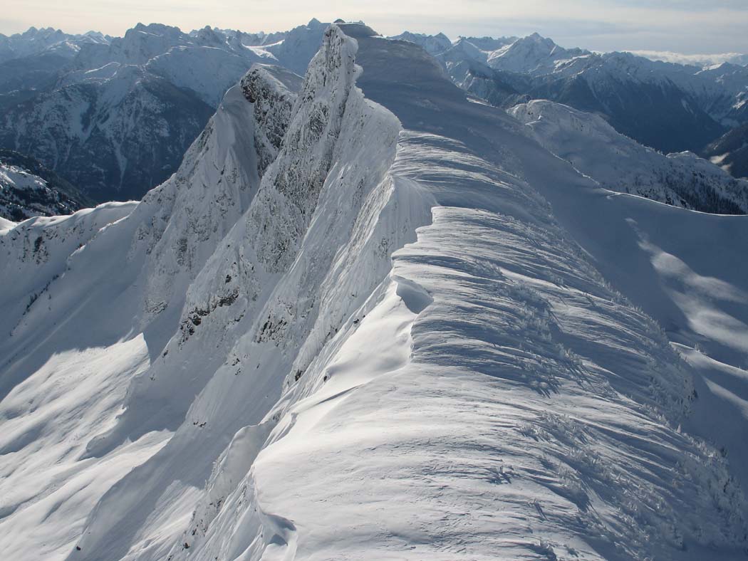
RRoost
Similar view to above from a plane, looking up the north ridge, taken March 1, 2006 by John Scurlock
Jay Creek left, Goodell Creek right
My X-Y conceptual beginning happened sometime in mid-April 1943 in Newhalem, Washington, a small, neat, company town on the right bank of the Skagit River in Whatcom County, the end of the road until 1952, and now the very heart of what became the North Cascades National Park in 1968.
The rushing, powerful, liquid sound of the Skagit is the white noise of my id. The first two cells of my being collided and fused with that river's resonance in the background, and I wonder if I still have a hard time distinguishing the sound of the Skagit from the sound of the first nine months of sloshing in amniotic fluid.
The Skagit flow is still a sound that rushes in the recesses of my brain, fueling, I'm sure, the pleasant persuasions of the id, that part of the psyche which is regarded as the reservoir of the instinctual drives and the source of psychic energy.
But climbing was not the passion in the 1940s and 50s when I was growing up in Newhalem, as it is now.
Those bitten by the First Ascent bug remember the ones they have made. R Roost was My First Ever First Ascent, and quite a big deal to me then at the age of 22 in 1966. In the scheme of things being done now in the North Cascades, and especially the world, this was a minor accomplishment, but it made me feel good in 1966, and still does. If I do have the FA here, it was because others walking by this peak before me, bent on the Pickets, slid under this top.
On July 12, 1966, I was home alone in Newhalem at the new house my mom and dad had moved into in 1961 after I graduated from Concrete High School and left for college. They eventually retired from this house in 1983, exquisitely located right on the Skagit River across from Newhalem Creek.
I was taking a summer off between my second and third year of medical school at the UW in 66, recovering from a wicked year. This was the first summer I'd rested from studies since I was a sophomore at Concrete High in 1959.
My folks and sister Reenie were away on a dad-driven education vacation by car from Newhalem to back east to evaluate the Seven Sisters colleges as possible places for Maurine to attend. Two days before this Roost trip, I'd climbed Sahale Peak with three of my medical school classmates in marginal conditions.
This July 12th day, 1966, I was delighted to awake to a perfect morning. I knew I wanted to do the peak along the high ridge north of Newhalem, between Ross Mountain (local term for Mount Ross on the maps) and the Southern Pickets. My goal was a 6705-foot summit at a wonderful location above the Skagit River, and recognizable far down the valley from Highway 20, first at a point between Marblemount and Rockport at Corkindale Creek, then again at about Diobsud Creek, and finally in full view as the corner is turned into Newhalem, upriver from Thornton Creek.

Roost from Stetattle Ridge
Jay Creek Face from ground
The Roost is a muscular, rocky, cliffy summit on the ridge that erupts straight out of Newhalem first dividing Goodell Creek from Gorge Creek, culminating at Mount Ross, then calming down a bit to dominate this side of Stetattle Creek. Its prominence on the new 1989 USGS Mount Triumph map is 865 feet (6705 minus 5840- saddle with Glee for the clean prominence). If you want to max the prominence, add 40' to bring it up to P905 feet. The NE Jay rib rises from 5200' to 6705' for a 1500-foot yet-unmet challenge. The SE summit has a classic rib-line technical climb of 1350'.
The softer southern subsummit of RRoost reminds me of Virginia, my mother, and the 6705-foot top makes me think of Jack, my dad. Jack began work with Seattle City Light in 1940 and moved to Newhalem in 1942 as a laborer (oiler) with the hydroelectric project on the Skagit River. A stickler for detail and a relentless student, questioner, and gatherer of information, he moved on up the civil service ladder on exams to become the first supervisor of Ross Dam and Powerhouse in 1951, and eventually managed all of the Skagit City Light Projects: Ross, Gorge in Newhalem (for 25 years), then finished his career at the Diablo plant where he re-tuned that project before retiring in 1983.
Mom was the "camp nurse" for the Skagit project from 1942 on, having received her R.N. degree at the UW in 1937. She was the primary-care provider in the Seattle City Light company town of Newhalem for 41 years (the nearest doctor being 35 miles away), administering childhood immunizations, attending the sick, delivering surprise babies, and triaging and stabilizing industrial, motor-vehicle, and wilderness accidents. City Light paid her a whopping, embarrassing $1 a day for her constant 24-hour on-call schedule. In 1983 my folks retired to Somerset in Bellevue .
When I started for RRoost in 1966 I had the first part of this trip wired, built on knowledge from previous forays up Goodell Creek, first with my dad, then various friends.
In 1964, cousins Tex and Monte Steere and I had actually set our sights on this very peak, only to discover when we climbed out of Goodell Creek to arrive at a spot on its north ridge above Jay and Stetattle Creeks that the goal we were shooting for was farther off to the north, Peak 7200+ (on the old map) High Ross (later Glee Peak), the highest peak on Ross Mountain ridge. So instead of turning south to do the Roost, we turned north to do Glee Peak (the way you feel when you get there). This name honors Glee Davis, son of Lucinda Davis who ran a road house near Diablo at the turn of the last century, and namesake of Davis Peak .
This 1966 adventure was my first solo climb, though it really wasn't truly solo, since our faithful family dog, Taffy, got talked into coming along. She was a wonderful hound mix, a solid, shiny, taffy-brown color in her youth when we got her from the pond in 1954 upon returning to Newhalem from Diablo. But by 1966 on this climb, her muzzle was grizzled at the age of 12. As a second-year UW medical student practicing my stethoscope skills in 66, I had diagnosed Taffy with a nasty grade IV/VI mitral-valve regurgitation murmur.
When she was a youngster, Taffy was a smart and powerful little dog with a muscular-beagle-like body and a face of content. I still have a clear image of her when our family was hiking the primitive trail up Newhalem Creek. Taffy ran ahead of us, checking things out, as young dogs do, and at one point when we were confronted by a man-high root end of a toppled hemlock blocking the trail, we watched in admiration as she hesitated just a hitch, cocked, then in one swift leap jumped up to the top rim of the root, grabbed the edge with her forefeet, and zipped over.
But on this trip to the Roost, at the dog age of 12, the human age equivalent of (x 7 =) 84, she was satisfied to follow along on my heels.
Taffy and I snaked our way through the alders sprouting on the abandoned logging road up Goodell Creek, and since my dad and I had scouted this route out a few years before on a feeble effort to go into the Pickets in 1963, I knew all the tricky turns at the forks in the trail.
From some old notes I see we drove 1.3 miles up the Goodell Creek Road from Newhalem in 10 minutes and parked. It took another 15 minutes (0.7 miles) to hike to what is now called Straight Shot Creek (flowing down a very interesting fault-line which slices from Goodell to Jay Creek see aerial photo). This was the first stream to totally obliterate the old logging road.
About 4 miles from the car we went over another major stream, then straight up hill, calling the watercourse Over-and-Up Creek. Two years before, my cousins Tex and Monte, and I were surprised to chance upon an obscure trail in the woods here, 30-vertical feet above the end of the old road bed. This made rapid work of the initial elevation gain. The new 1961 Climbers Guide described this approach and talked of locating this path at a tall spar tree, a landmark that we could not identify in 1966 (or '64).
There were a couple of curious little humps, followed by little dales at 3100 and 3200 feet along this approach ridge where the path finally totally petered out in 1966 (flaggers have since criminalized the route all the way to Terror Basin).
From the 3200-foot hump, Taffy and I bore right towards the creek around a bluff straight ahead, but generally headed straight up, reaching a curious talus tongue licking down into the old growth at 5200 feet, 300 feet below the usual 5500-foot tree line.
I wanted a picture of Taffy here but whenever I positioned her, she seemed intent to follow me back to where I wanted to take the picture from, until I finally figured out that if I left some food for her, she'd stay and eat. So discovering this, after placing the bait, while she nibbled, I moved uphill and shot. We climbed on, with tantalizing peeks through the trees over to The Stump (Pinnacle Peak on the map), and finally topped out of the trees to scramble on over glacier polished gneiss, dotted with heather patches and alpine gardens to eventually reach the ridge crest overlooking Jay Creek.
As we rose above timberline, Triumph and then Despair poked up, then a view across to Trappers Peak , X Mtn, and the original Damnation, and shortly I was able to look over to Big Devil and down the Skagit Valley . Soon the rock Stump popped up again, then the Southern Pickets. These mountains were already becoming familiar friends to me. It took us 5 hours to make the climb (including driving) from Newhalem to the summit.

Taffy atop the Roost
Triumph and the old Damnation behind
Finally atop the 6705-foot peak, I did the food positioning trick with Taffy several times to get her in the panorama as I shot around the horn. High Ross ( TMJ Peak -- Glee Peak ) to the right of the Pickets, then Elephant Butte, then Davis, then the Backyard and down to the rather insignificant looking Ross Mtn. I held out my dad's Argus C-3 camera at arms length and fired a shot of myself with the Pickets in the back and a steep shot down into Jay Creek before heading down. I left behind my name and Taffy's, and date in a skinny glass olive jar.

JR on top, July 12, 1966
The north ridge of the Roost still had a rim of snow which made for a rapid descent. The east face from here looks to be a good challenge, and has not yet been tried, even as I review this in 2006.
I used an old canvas fishing sack of my dad's as my pack. Taffy and I loped down the hillside in quick fashion making the return to the car in 2 hours 45 minutes. Near the car a side channel from a little creek had formed a nice cooling pool in the Skagit gneiss. Taffy was so whooped, hot, and foot-weary that she walked right into the middle of it and lay down with only her head sticking up.

Taffy in cooling pool
That's the simple story of the RRoost. I've returned to climb it five more times.
7/6/1970
Gary Mellom and I came back here four years after my first 1966 climb on our exit from the Pickets. We were sad and annoyed to find that the 1966 register had disappeared. Who would do something like this, we wondered? One possibility we speculated was that the original summit register was tossed off the edge by geologists who helicoptered through the North Cascades in 1966-67 doing a rock inventory for a report to Congress to make sure the US wasn't overlooking any great mineral claims before turning this area into a National Park.
8/17/1975
I returned again with Alex Medlicott in a whiteout and continued on a traverse over to Ross Mountain (while our fathers, David Stonington, and Theresa returned home from high camp).
9/11/1976
Climbed this again with my dad, Jack, Terri, and Joyce Hagan, so some more Ropers could say they'd climbed the Roost. It was on this descent that my dad announced that this would be his Last Mountain. Although he's climbed a summit with me every year since [until 2005] just to stay in shape, this actually was his last good peak.
1/4/1981
Finally (for now in 1985) Russ Kroeker and I made the first winter ascent of this peak on January 4, 1981. If I'm not mistaken, this is the only peak in Washington where the FA and FWA were made by the same person.

RRoost
from Sourdough, April 9, 1978 (JR on snowshoes)
9/6/1993
As of this review in 2006, my final climb to date on this peak was 9/6/93 with my Group Health Alpine Society (GHAS) doc buddies (David Stonington, Charlie Janeway, Ted Hegg, Howard Putter, Don Avriett, and Marshall Eaton ) on my 6th ascent of this peak.

The Roost'
from Trappers Peak, January 23, 1977 (very light snow year)
Roost (L), Davis (R center), Jack (R), with Ross hiding at low point between Davis and Jack
Straight Shot Creek in center

RRoost
from Trappers, January 23, 1977

Roost, NE (Jay) Face
from Glee Col
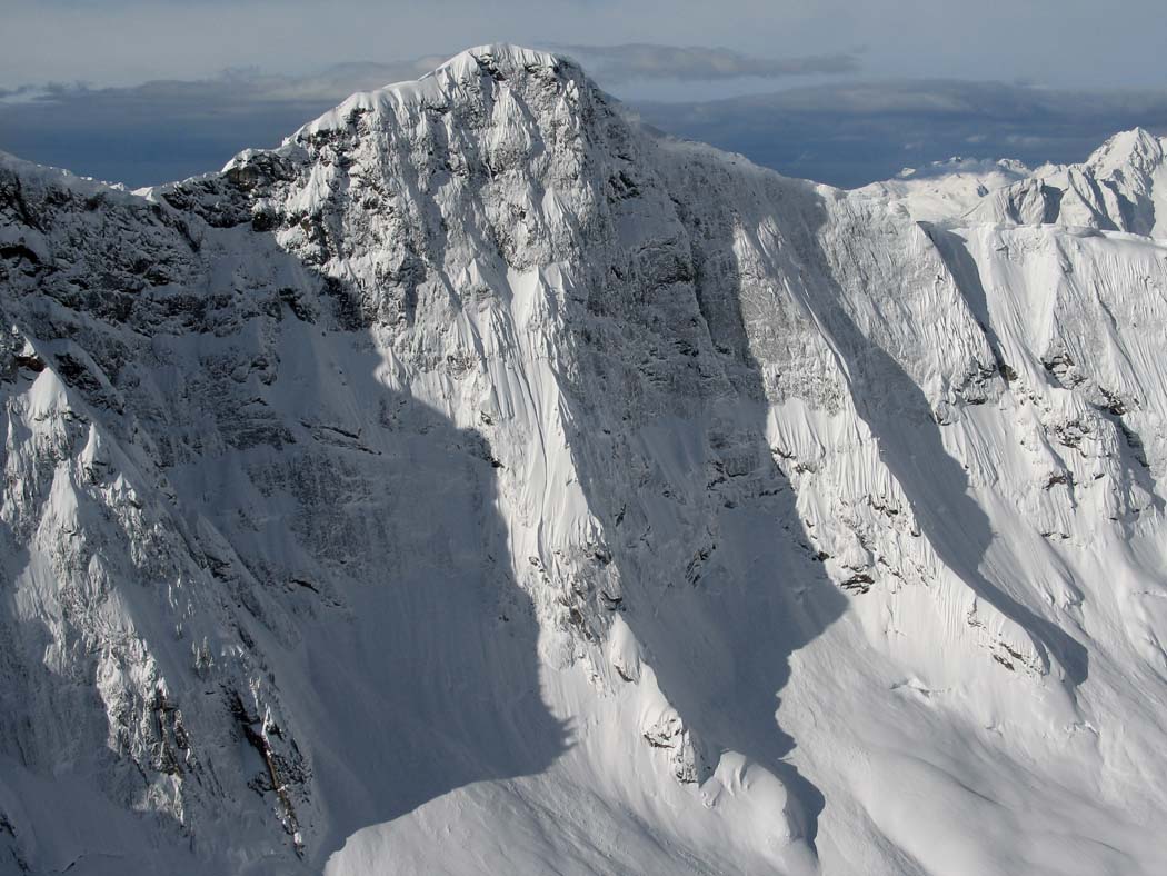
The Roost
NE (Jay) Face on March 1, 2006 by John Scurlock

Three Generations on the Roost, July 26, 2009

Jack's Tombstone
Copyright 2004-2006, John Roper. All Rights Reserved.