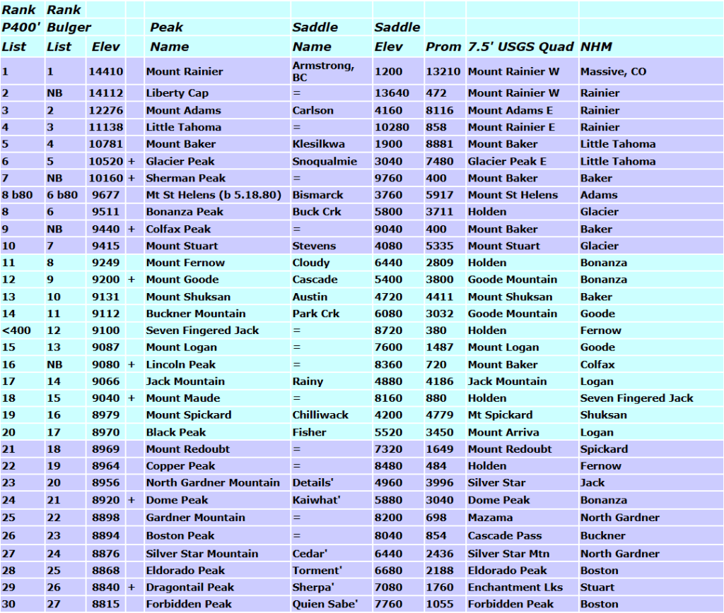
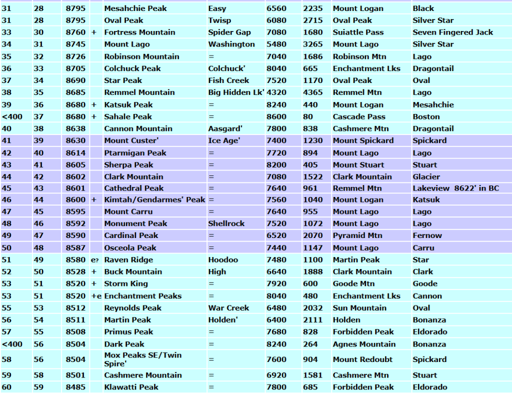
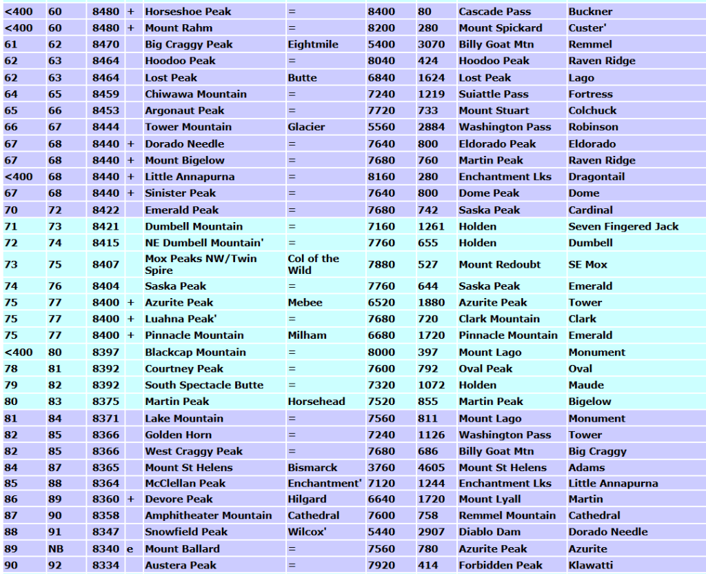
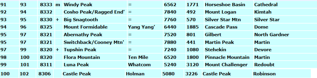
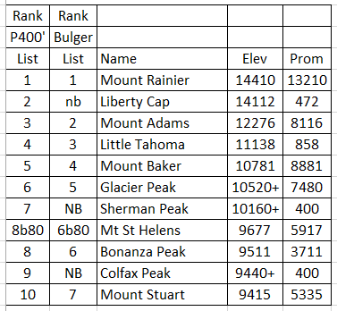
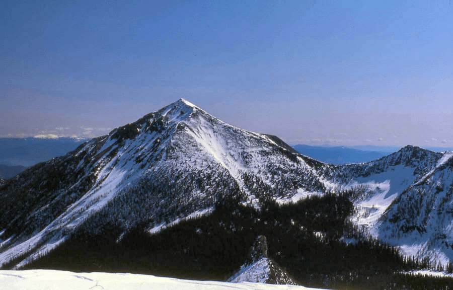
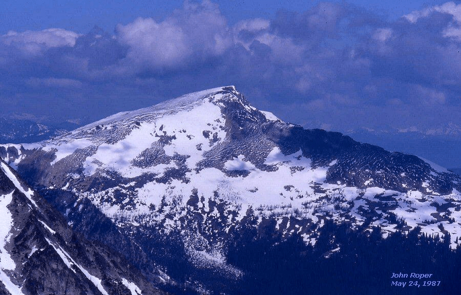
Comparison of the Bulger Top 100 List with the 400-Foot-Rule List by Clean Prominence. These are traditional, stable, historic period-piece lists, based on the USGS maps of the day (prior to 2001).
John Lixvar (and John Plimpton to 8500 feet) created the great Top 100 Bulger List in 1976.
Bulger Rules:
1. Minimum 400-foot, clean-prominence-based list.
2. Excluding volcano subsummits with <800 feet of prominence. (Liberty Cap, Sherman, Colfax, Lincoln).
3. Including high, map-named, non-volcanic summits over 8320 feet with 400′ of prominence. (Seven Fingered Jack, Sahale, Dark, Horseshoe, Rahm, Little Annapurna, Blackcap).
The one-rule list (clean 400-foot prominence) WA Top 100 Peaks with prominence data, additional peaks, saddles, and next higher mountains (NHM) was developed 1987-2001 by Jeff Howbert/John Roper.
Prom: Prominence is the elevation difference between a peak and the lowest contour that encircles the peak and no higher point.If water were to rise to this lowest encircling contour, it would isolate the mountain as an island, and the height of the island would be its prominence. This is a clean prominence list, but prominence calculations could be done from these surveyed pass elevations: Stevens (4056), Cloudy (6438), Whatcom (5206), Maude/Seven Fingered Jack (8158), Hilgard (6638), Twisp (6064), or road sign pass elevations not shown on the latest maps: Snoqualmie (3022), Rainy (4855), Washington (5477), or Big HiddenLake (4316).
Peaks with the same elevation are given the same rank.
Calculations were done with maps available in 2001.
NHM: Next Higher Mountain (credit Greg Slayden)
NB: Not on Bulger List because of volcano subsummit exclusion rule
and Mount Ballard map error
<400: Peak does not meet 400-foot prominence rule.
b80: Elevation and rank of Mt St Helens before May 18, 1980 eruption
‘ Unofficial name, not on USGS map
= Pass has no official map name. Kaiwhat Pass is official, but not yet on USGS map .
e Errors on 7.5′ quads. Ballard: Cross-hair is on true summit 0.2 miles SSE and ~40 feet higher than 8301′ elevation shown on map.Enchantment: The true summit is the NE peak shown as the 8480+contour on 7.5′ quads, but surveyed at 8520 on older 15-minute quads.Raven Ridge: High point may be 8572′ east summit, rather than the 8580 summit on USGS Martin Peak.
TOP 10 Peaks
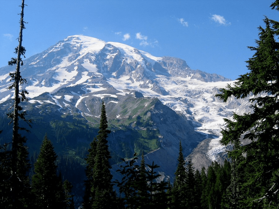
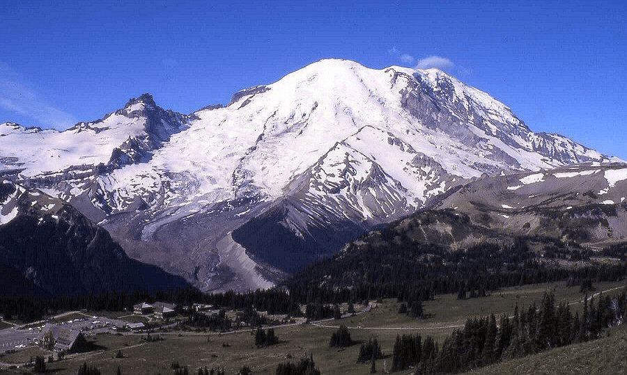
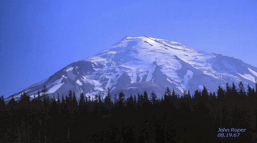
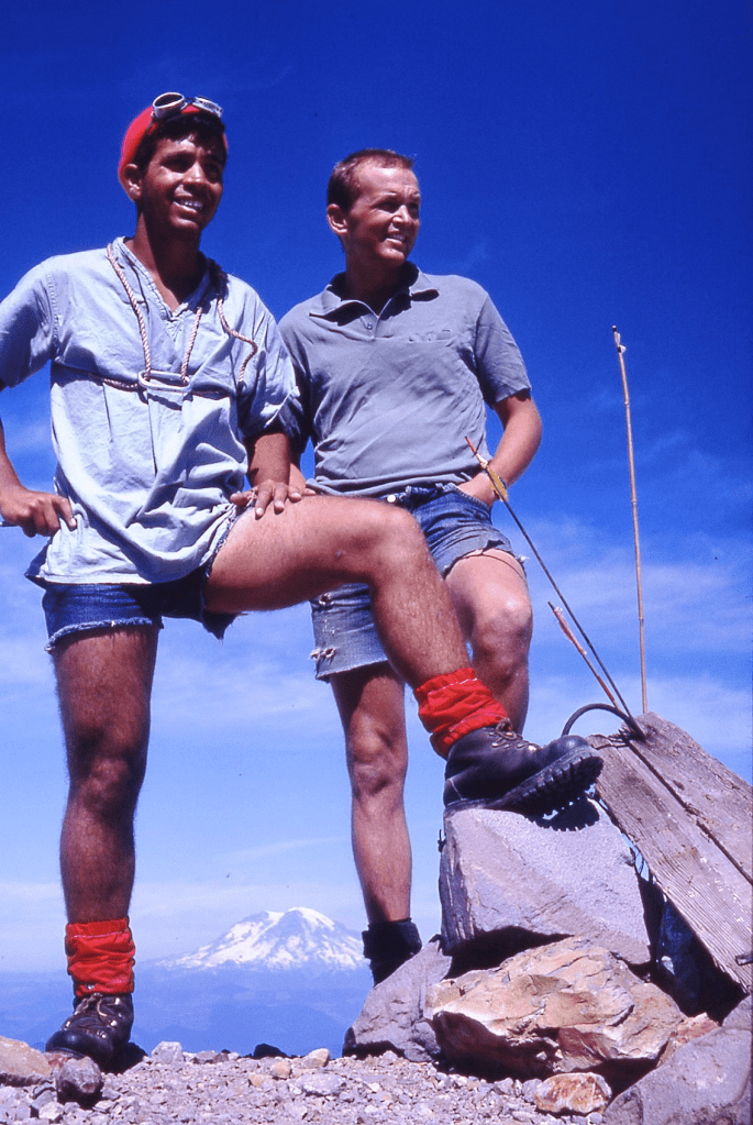
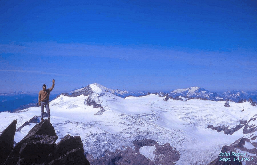
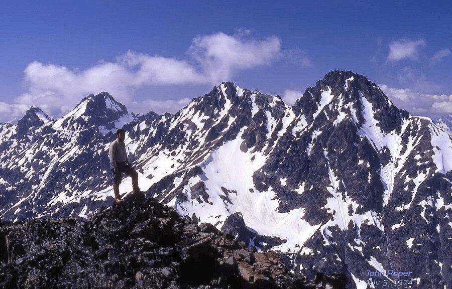
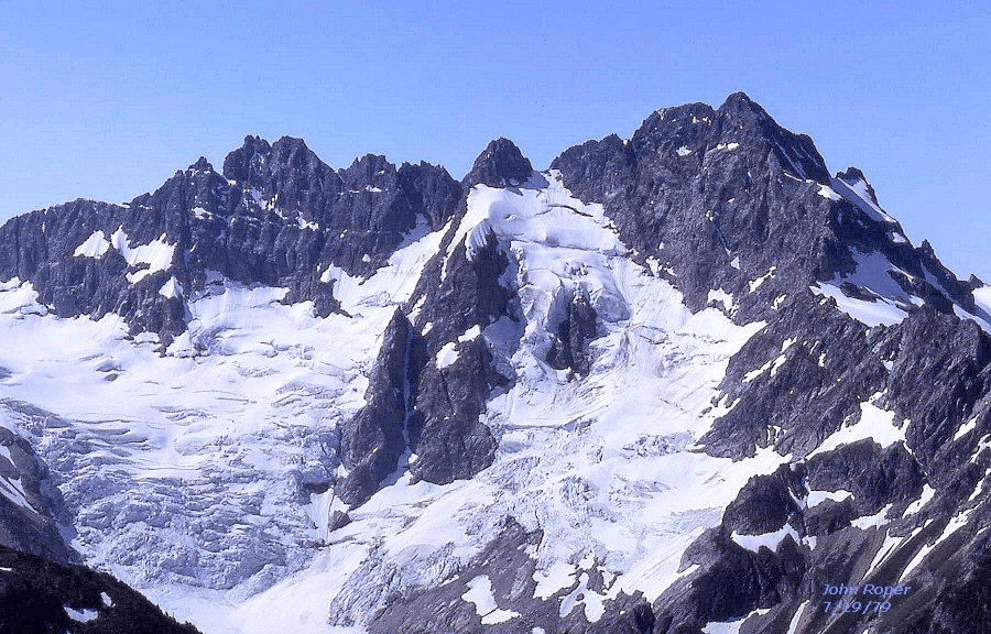
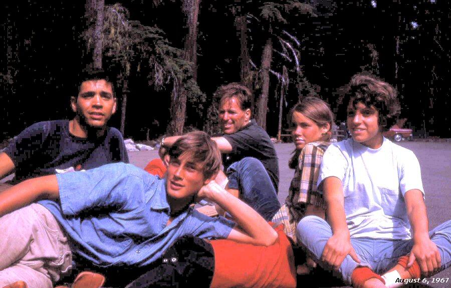
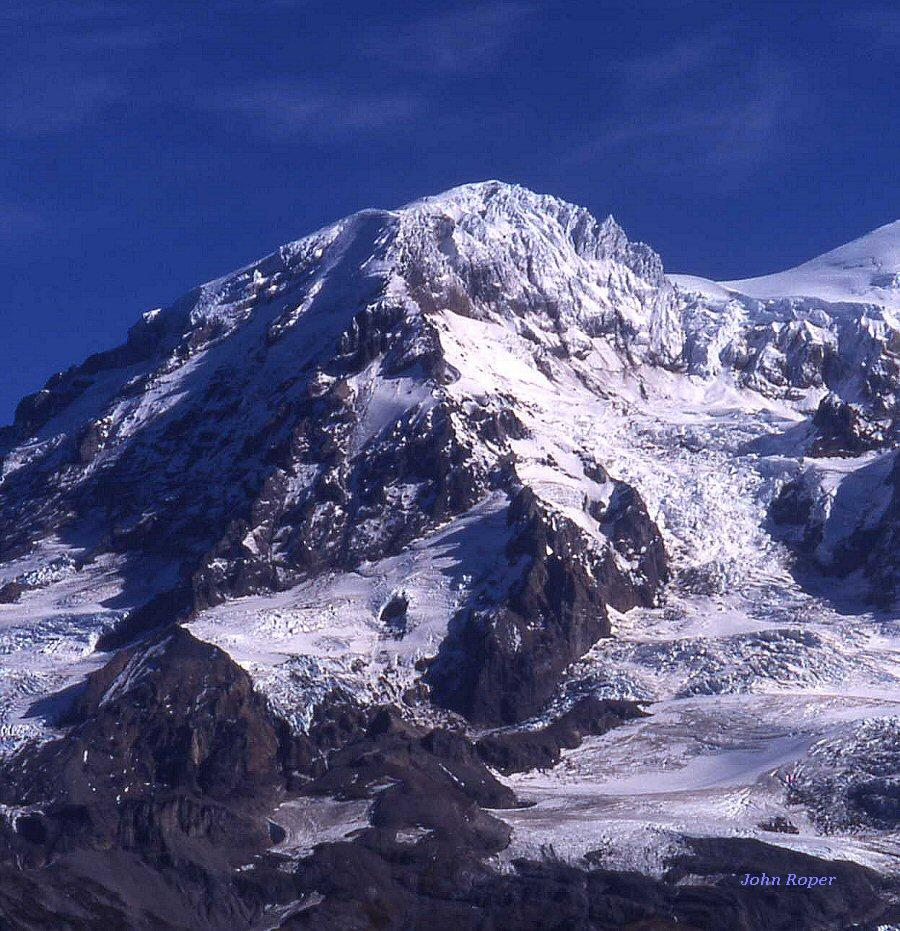
NB: Not on Bulger List because of volcano subsummit peculiarity b80: Before the May 18, 1980 eruption of Mt St. HelensMOUNT RAINIER 14410′ / Prominence 13210′ viewed from the south, just west of Paradise. The apparent high point in this photo is actually Point Success 14158′ (with only 118 feet of prominence). The 14410′ top (Columbia Crest) is the white bulge just right. Nisqually Glacier is the tumbling icy beauty. This 13210-foot-prominence value is 21st-greatest on Earth, and more than K2. Map. Enlarge.MOUNT RAINIERfrom NE, above Sunrise (the highest paved road in WA). Little Tahoma (L). Huge Emmons Glacier (largest glacier in Washington, and the lower US)leads to the 14410′ top. Liberty Cap (R).Enlarge.(L) to (R): John Roper, Charlie Johnson, Chuck Welsh, Hurley Johnson, and Maurine Roper, August 6, 1967 after climbing Rainier. Enlarge.
I was lucky to climb Rainier for the first time with Chuck Welsh who, in the late 1940’s made the first ascents of Liberty Bell, South Hozomeen, Golden Horn, Big Snagtooth, and Wamihaspi/Cornice Peak. My sister Maurine (R) was an Annie Wright Seminary schoolmate of Chuck’s s daughter, Hurley. The three teenagers did great, and I was amazed at how powerful an “old man” of 42 could be.
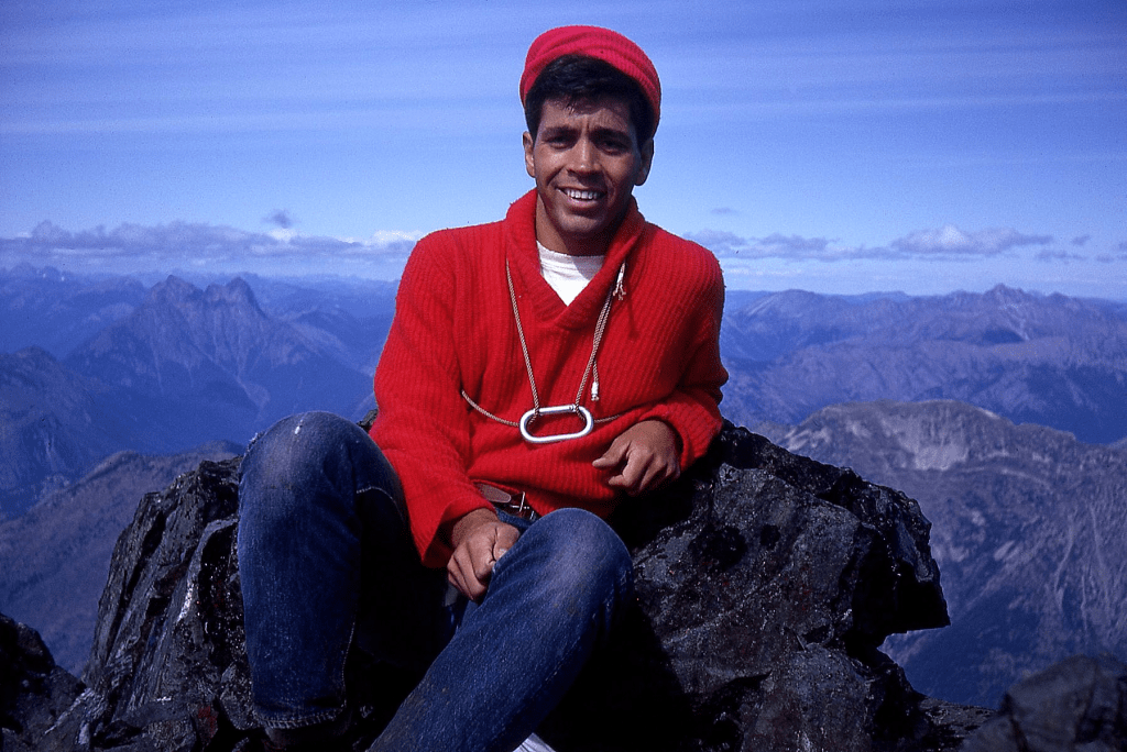
LIBERTY CAP 14112′ / P472 from SW. Pretty nice summit, with a decent 472 feet of prominence, but not on the Bulger List because of the volcano subsummit exclusion. This was my final Top 100 peak by clean-400-foot prominence, climbed July 21, 1991, thanks to Gary and Joel Mellom.Enlarge,
Sunset Amphitheater is the high bowl in the sun, with the cascading Puyallup Glacier icefall right. Sunset Ridge is the rocky route that leads to the summit, with the upper lobe of the South Mowich Glacier at its base. Mowich Face is in the left shadows with the Edmunds (not Emmons) Glacier below it. Ptarmigan Ridge is on left skyline. It’s a lot easier from the other side.Map.
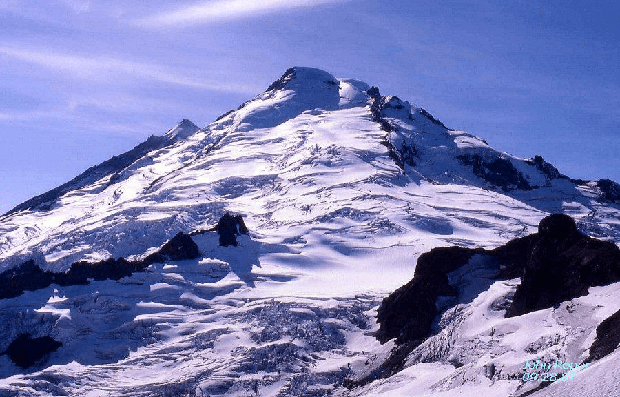
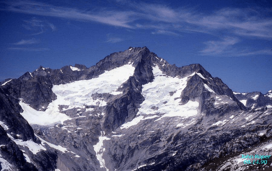
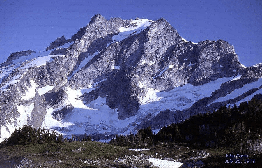
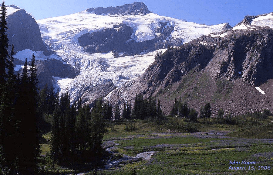
MOUNT ADAMS 12276′ / P8116from SW, on Flattop Mountain June 6, 1992. The Pinnacle (L), Pikers Peak (R). Usual route is up the right slope.Map.LITTLE TAHOMA 11138′ / P858 NW Face, looking across the Emmons Glacier from Camp Schurman. This is the only volcano subsummit that counts on the Bulger List because of the (Lix)variation that it has >800 feet of prominence.MapMOUNT BAKER 10781′ / P8881from NE with Park Glacier high, Rainbow Glacier in foreground. Sherman Peak pokes up on left. Cockscomb, the notched crag high right of summit, is one of my last remaining named summits to do in the Skagit drainage. Anybody interested?Map
Winter aerial photos of Baker by John Scurlock will knock your socks off.
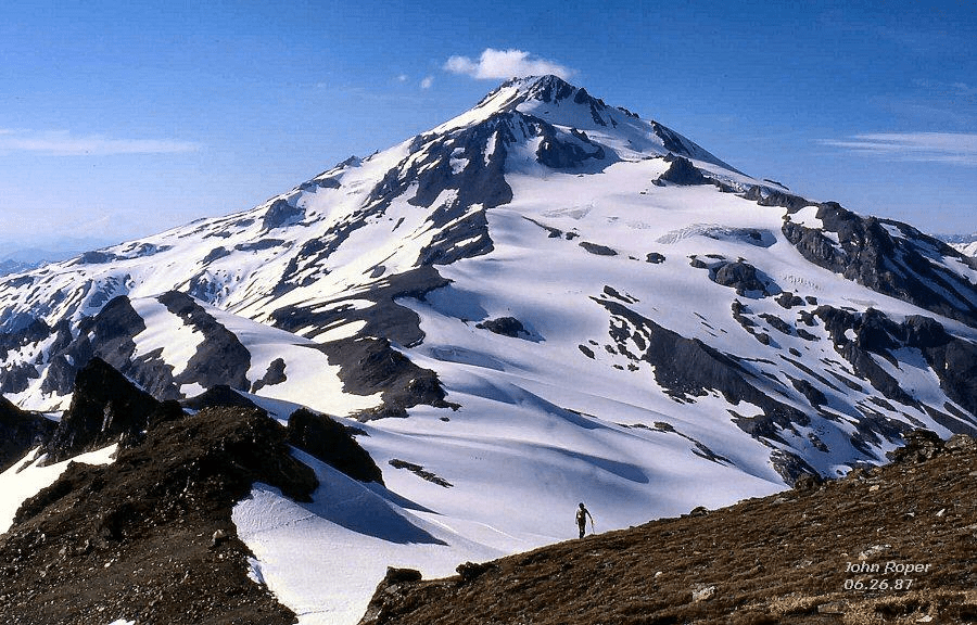
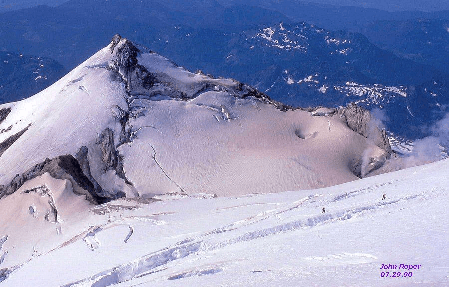
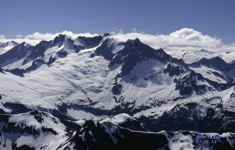
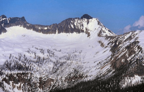
GLACIER PEAK 10520+ / P7480South side, from Kololo Map,SHERMAN PEAK 10160+ P400 Lou Zibelli and Charlie Janeway pass by steam plumes emitting from Summit Crater with sulphur stain on snow, nearly to the top of Mount Baker. Silas Wild skied off of Sherman to become the second person to finish the WA Top 100 by the Clean 400-Foot prominence rule on 6/2/2007. Map
Spring aerial photo of Sherman by John Scurlock: 1
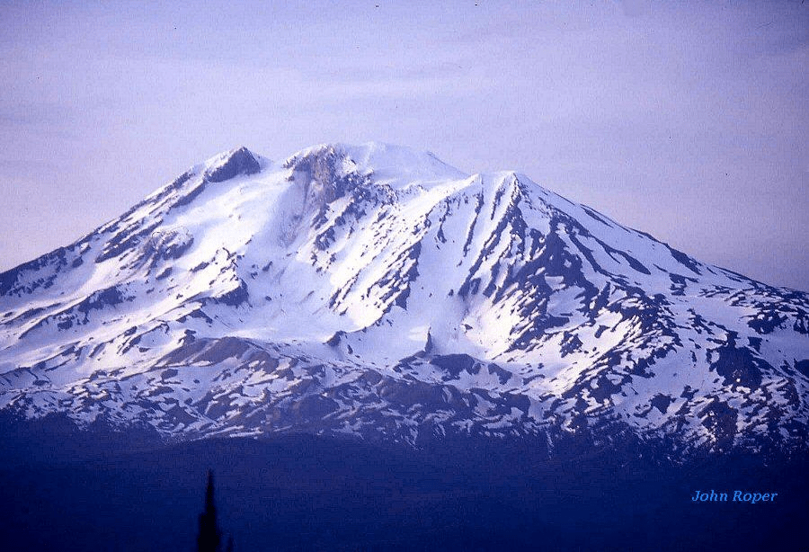
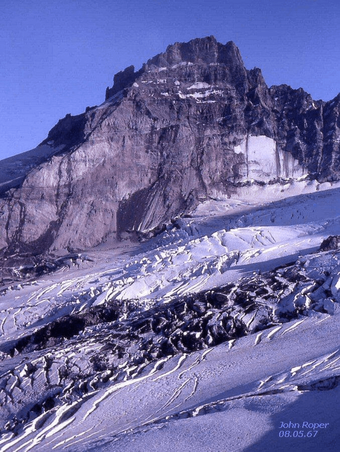
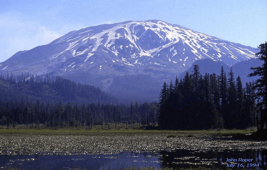
MOUNT SAINT HELENS 9677′ / P5917 North side before the May 18, 1980 eruption. The left skyline over the Dogs Head was a fabulous spring ski. Other features no longer with us after the cataclysm are the crevassed Forsyth Glacier on left, Leschi Glacier flowing between the Big and Little Lizard ridges, and Loowit Glacier under Goat Rocks on right skyline.Pre-eruptive Mount Saint Helens. Phil Dahl and I climbed via the Lizard routes (R) on August 19, 1967.Atop 9677′ old St. Helens with Phil Dahl August 19, 1967. 1312 feet of elevation were lost in the 1980 eruption.Bill Affolter and Dave Stonington head up St. Helens on May 1, 1977. Also skied it on
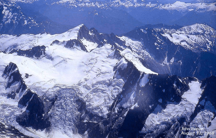
BONANZA PEAK 9511′ / P3711. Company Glacier, north side Map.
Aerial photos of Bonanza by John Scurlock on October 27, 2004: 123 4
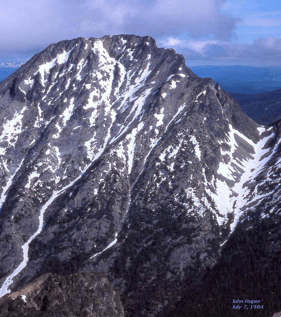
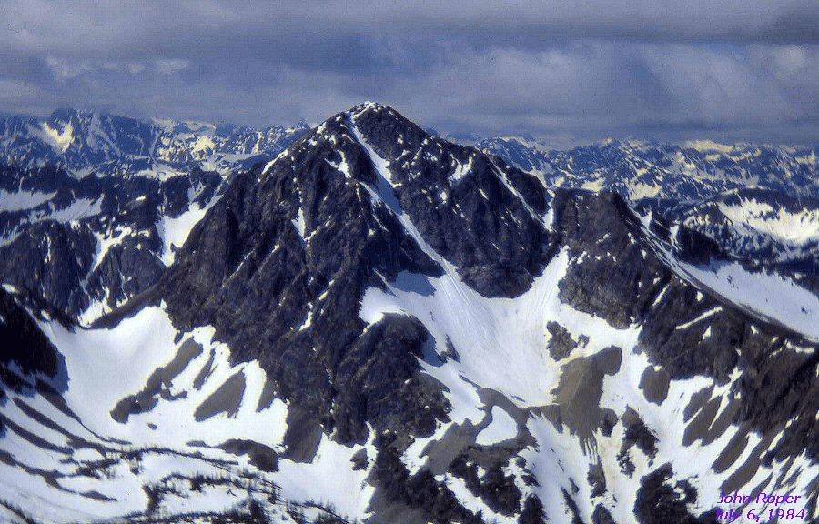
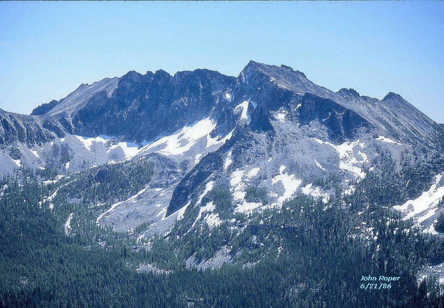
Bonanza’ standard route is via Mary Green Glacier here, up the highest right-leaning snow thumb, then the final rock wall. This is the highest peak in Chelan county, and the hardest of the 39 County High Points in the State, and the highest non-volcanic peak in Washington.COLFAX PEAK 9440+ / P400on descent of Baker. Tragic rescue and retrieval in progress this day. (lower left). Map.MOUNT STUART 9415′ / P5335from NE. The full 2800-vertical foot North Ridge dominates with Ice Cliff Glacier left, Stuart Glacier right.Map.
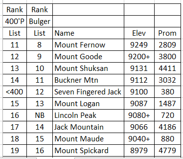
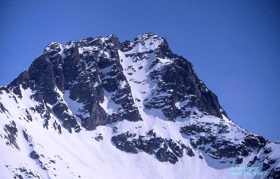
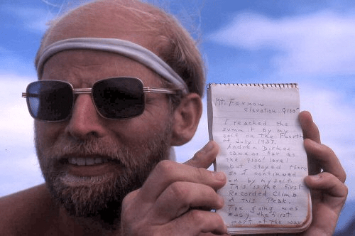
<400: Bulger Top 100 peak with less than 400 feet of prominence. NB: Not on Bulger List due to volcano subsummit exclusion. MOUNT FERNOW 9249′ / P2809from the North, bookended by Copper Peak (L) and Seven-Fingered Jack (R). Map.*
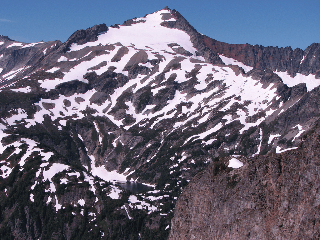
MOUNT GOODE 9200+ / P3800. The famous NE Buttress of Goode starts from the left hand rock toe, viewed from the NE. John Lixvar (Lizard) finished his challenging list on Goode in 1987 from the other side. Ten years later in 1997 this was Jeff Hancock’s last Bulger peak.
Map* Local name (Mount Goode) differs from map name.
Winter aerial photos of Goode by John Scurlock: 1234
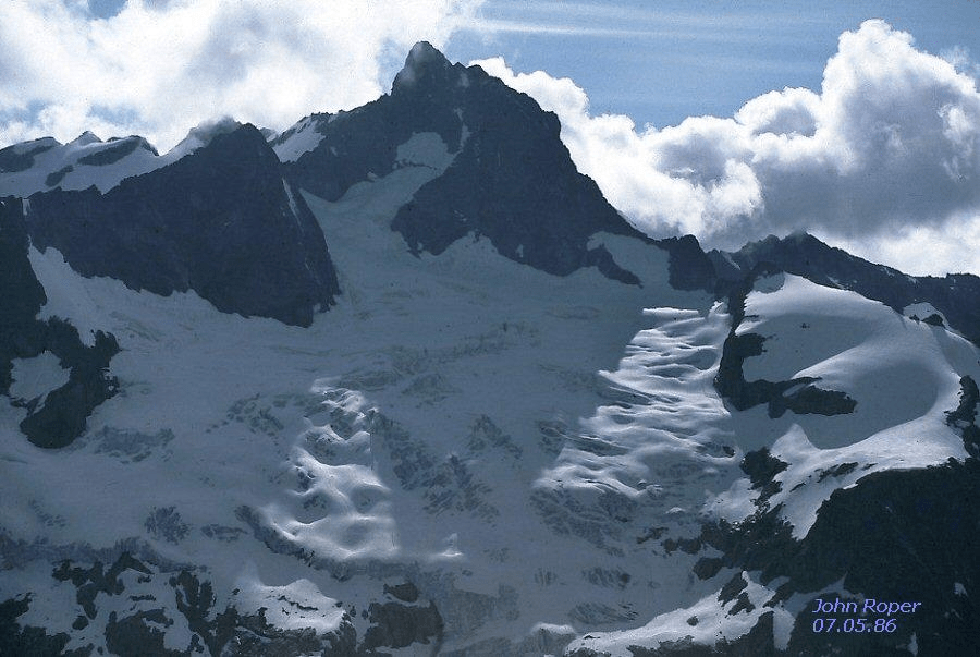
MOUNT SHUKSAN 9131′ / P4411 from Table MountainShuksan summit with Phil Dahl Aug 13, 1967.
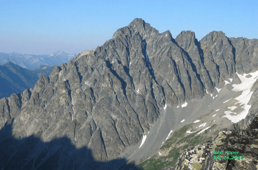
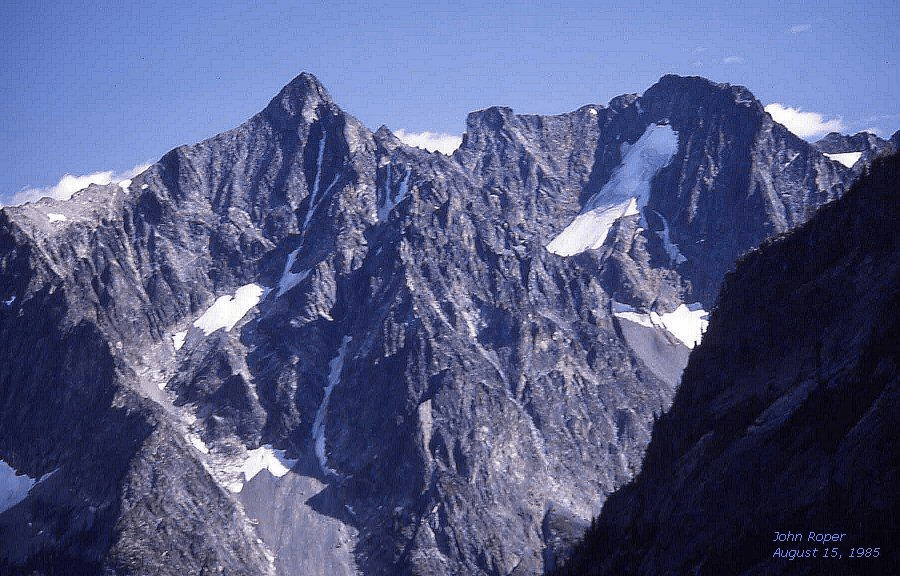
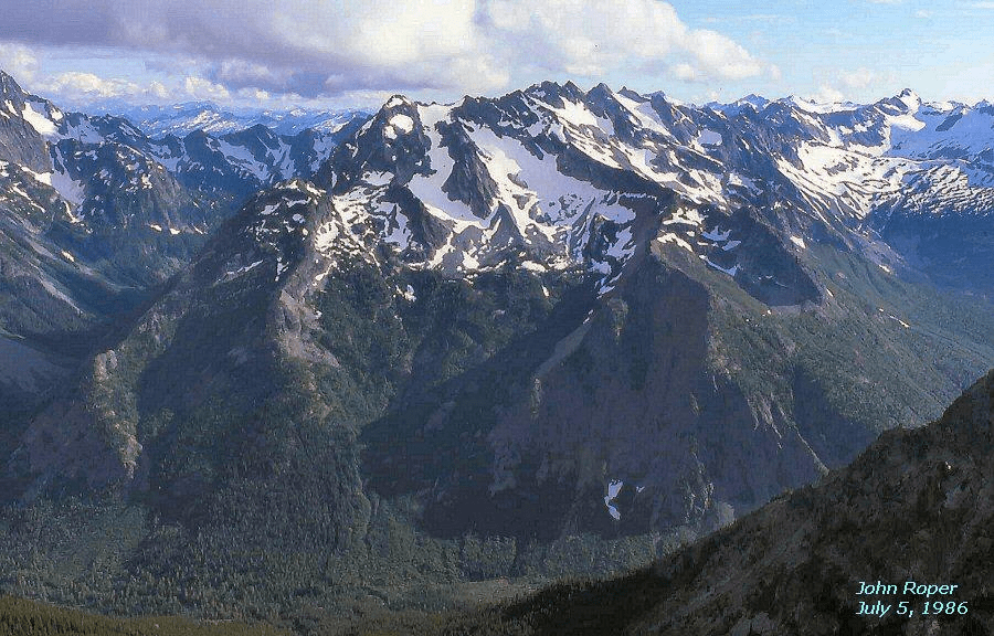
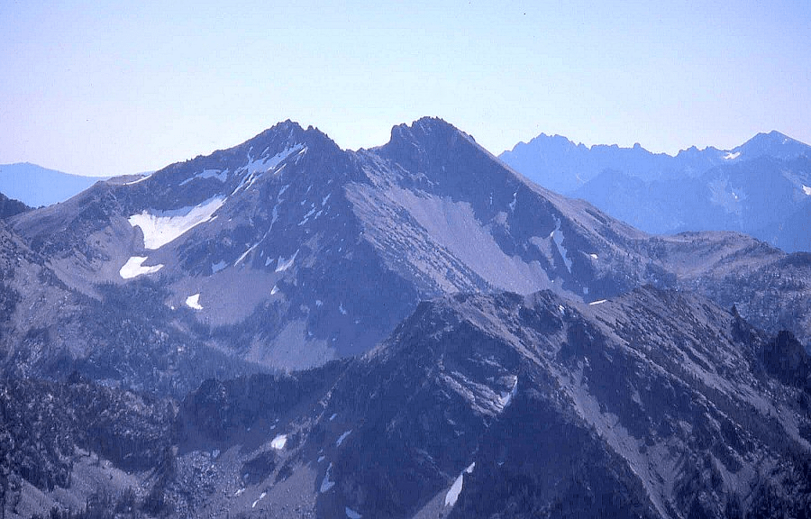
The Boston Glacier on the NW side of Buckner is the largest in the North Cascades at 7.0 square kilometers.SEVEN FINGERED JACK 9100′ / P380 from SE on Spectacle Butte. MapMOUNT LOGAN 9087′ / P1487 from the East, Douglas Glacier side. Map
Winter aerial photos of Logan by John Scurlock: From NW, North, West
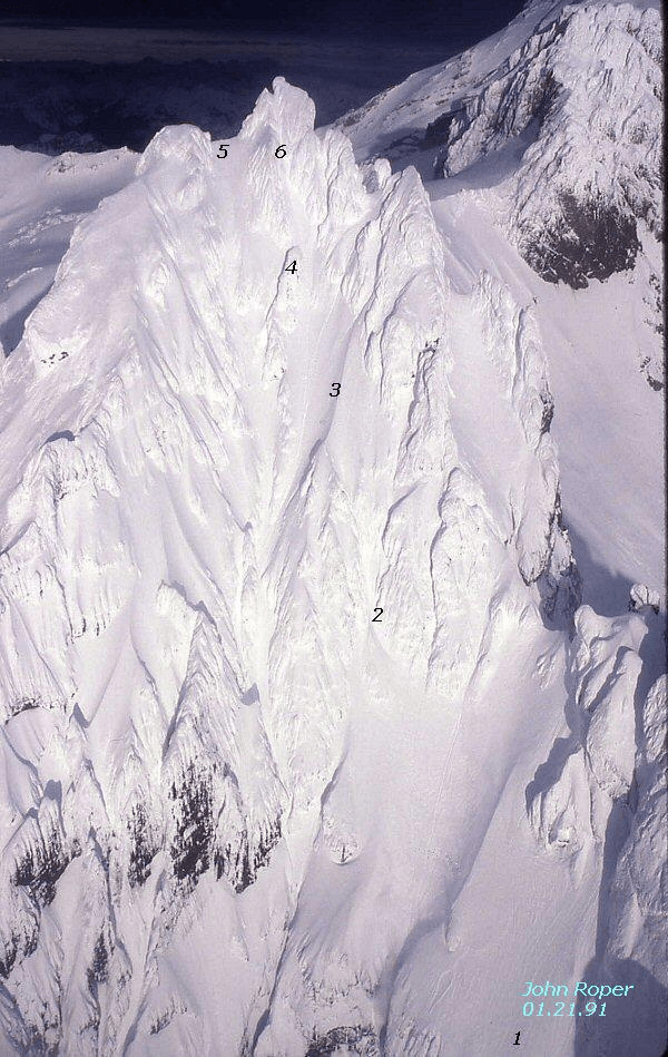
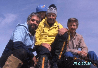
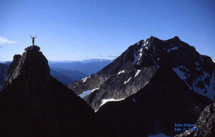
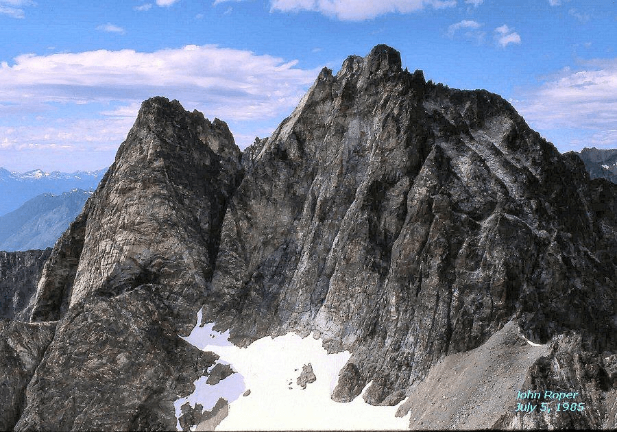
LINCOLN PEAK 9080+ / P720 from Colfax Peak. Not Bulger-worthy. Note Assassin Spire to right. It’s nbc (at 2004 writing). Lincoln could have been the reason John Lixvar declared that volcano sub-summits with less than 800 feet of prominence did not qualify for his list, so he’d never have to set foot on this monster. Later I kidded Lizard that he had invoked the “John Wilkes Booth Proviso” on Lincoln, assassinating it from his list. MapLincoln. SW side, with Colfax Peak upper right. On June 25, 1989, Reed Tindall, Silas Wild, Dick Kegel, and I came up from the lower right (1), into the “X Couloir” (2), then up the faint snow arete (3), angling to the “Leaning Tower of Pisa” (4), then to the high left notch at first sky (5) where we worked our way right to the top. We descended straight down the gully below the summit (6) to our tracks at the tower. This is one of only two aerial shots from my camera in this collection. All the rest of my photos were taken from the ground, although telephotos sometimes give an aerial feel. Summit party on Lincoln after 4 hours of 4 tight sphincters, June 25, 1989.John Roper, Dick Kegel, Reed Tindall, and Silas Wild. It was another 4 hours down. Lincoln was my last Top 100 Peak with 500 feet of prominence, but that’s another list.
Winter aerial photos of Lincoln by John Scurlock: 1234
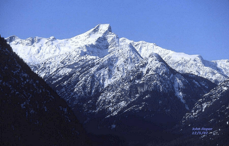
JACK MOUNTAIN 9066′ / P4186. Typical view from Highway 20 above Diablo Lake. Dave Creeden saved Jack for his last Big Boy in 1997, as did Martin Shetter who soloed it in 2006, 18 years after climbing 35 Big Boys in 1988.Another solist atop Jack Sep 6, 1967
Winter aerial photos of Spickard by John Scurlock: 123
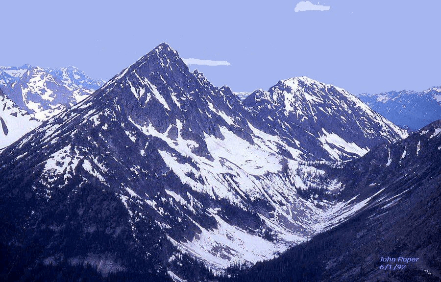
BLACK PEAK 8970′ / P3450 from north at Silent Lakes on route to Mount Arriva
Winter aerial photo of Black by John Scurlock: From NW
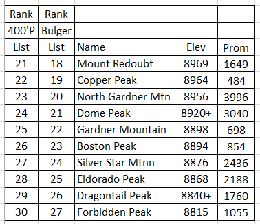
Peaks 21-30
MOUNT REDOUBT 8969′ / P1649 from EastRedoubt from N. Map.
Winter aerial photos of Redoubt by John Scurlock: 1234
COPPER PEAK 8964′ / P484from WSW on Genius. Silas Wild, Bob Tillotson, and I did a new route on Copper up the gully starting at the lowest central snow patch, going right into the next gully over at the small snow patch, then to the left ridge and up, on September 16, 1984. We came down the prominent gully right below the summit which is the way to do it, from this side. MapNorth Face of Copper (L), Fernow (R)NORTH GARDNER MOUNTAIN 8956′ / P3996 is the pyramid on right from the East, with Gardner Mountain left center MapDOME PEAK 8920+ / P3040from SE, at Ross/Kaiwhat Pass. Dome was Dick “Kangaroo” Kegel’s last Big Boy in 1988. Map
Winter aerial photos of Dome by John Scurlock: 12345
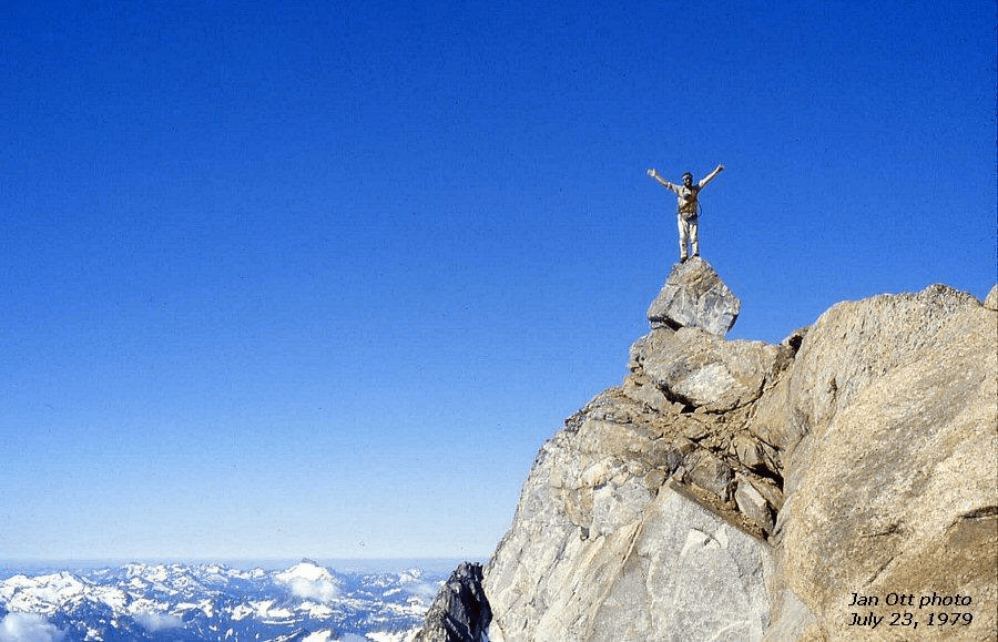
Dome Rock. Jan Ott took this photo of me on the famous Dome Rock, July 23, 1979. The summit boulder had “disappeared” by 1985.GARDNER MOUNTAIN 8898′ / P698 is the rounded, central summit, viewed from South, above Wolf Creek, on a traverse from Abernathy. North Gardner is the left pyramid. MapBOSTON PEAK 8894′ / P854on left, from Forbidden. Quien Sabe Glacier named by Austin Post (Spanish for “who knows?”), playing off Doubtful Lake for a prospector’s mine claim here, and Sahale Peak center, Bonanza (R). Billie Butterfield ended her quest for the Top 100 in 2000 on Boston. Map
Winter aerial photos of Boston by John Scurlock: 12
BOSTON PEAK from Sahale. SILVER STAR MOUNTAIN 8876 / P2436from the West. Lage Wernstedt climbed and named this in 1926, probably from this perspective. Silas noted his name-inspiring Silver Star on the face. MapELDORADO PEAK 8868′ / P2188from Forbidden MapELDORADO PEAK 8868′. Hard to beat those aerial views–besides Lincoln this is my only other. The 1200-foot McAllister Glacier Ice Fall is the finest in the North Cascades. The contrasting aspects of Eldorado are striking.
Wintery aerial photos of Eldorado by John Scurlock: 12345
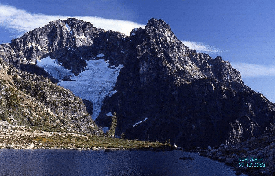
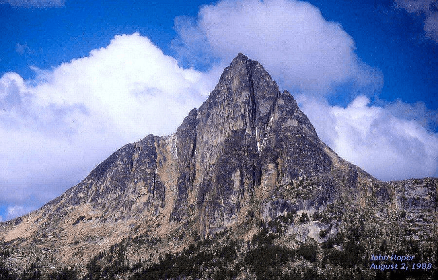
DRAGONTAIL PEAK 8840+ / P1760NW Face from Colchuck MapFORBIDDEN PEAK 8815′ / P1055from Boston on memorial climb Map On August 18, 2006, Fay Pullen became the 25th person to finish the Bulger List on this peak. One of Fay’s many claims to fame is that she soloed 72 of the Top 100 Peaks in WA.
Winter aerial photos by John Scurlock (who obviously loves shooting this mountain): 12345
Peaks #31-40
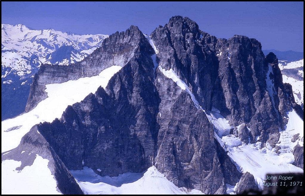
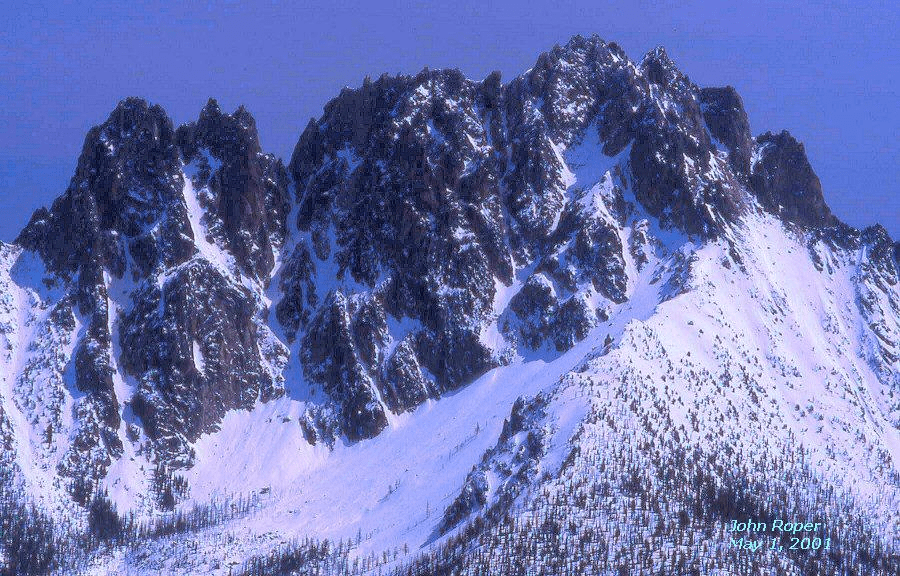
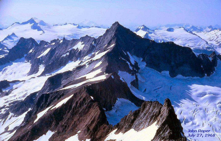
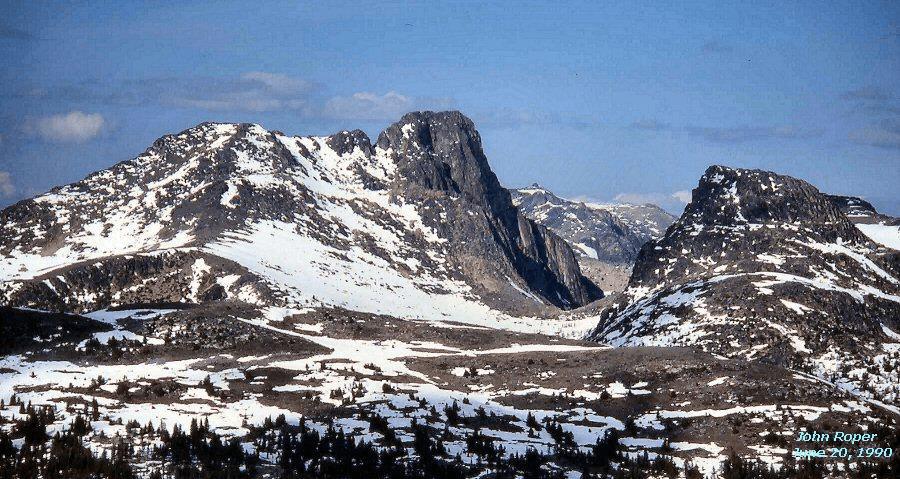
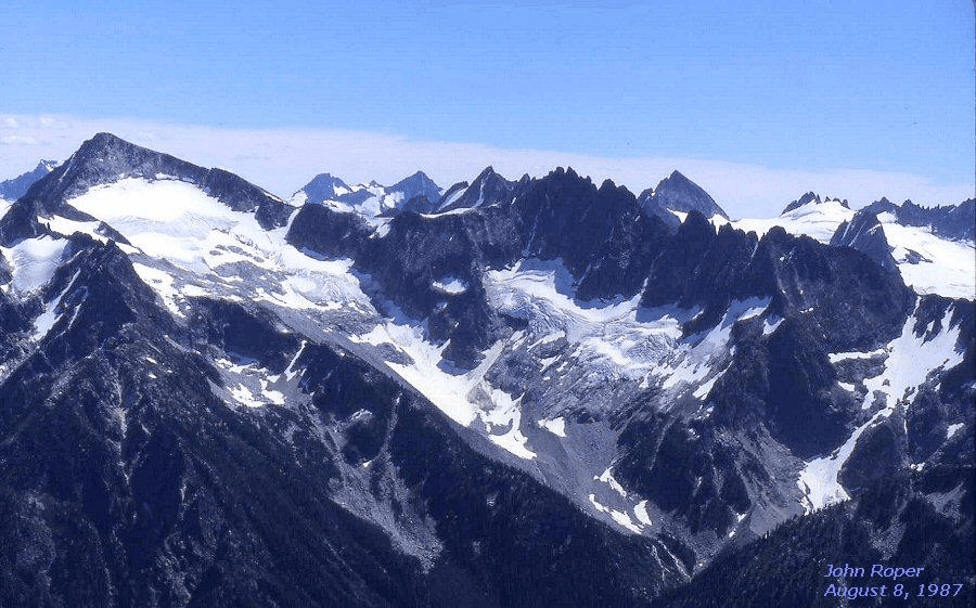
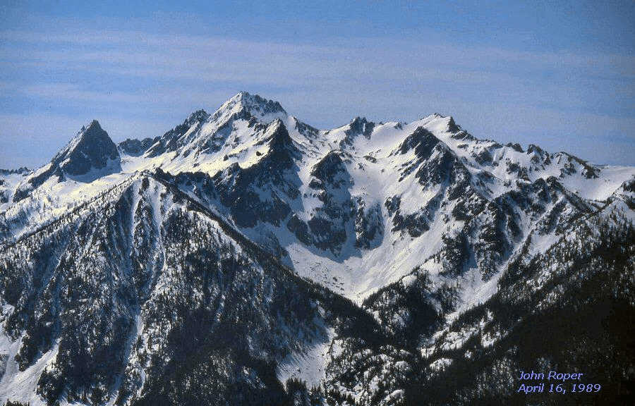
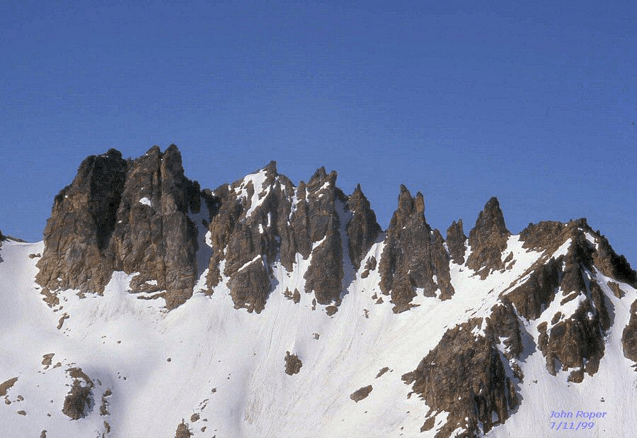
<400: Bulger Top 100 peak with less than 400 feet of prominence Peaks with the same elevation have the same rankMESAHCHIE/PANTHER PEAK” (L) 8795′ / P2235 KATSUK PEAK/MOUNT HOLYOKE’ (R) 8680+ P440 from WNW, on Gendarmes/Kimtah’ Peak on Ragged Ridge. Panther Creek (L), Fisher Creek (R). Both the 1949 and 1961 editions of the “Climber’s Guide to the Cascade and Olympic Mountains of Washington” had the same barebones beta:
“Ragged Ridge (ca.7600-8400)
An E.-W. ridge of high, barren peaks located on the Fisher-
Panther Creek divide.
Route. Base camp is made in the Fisher Creek basin 1 1/2
miles W. of Easy Pass (22 miles from Diablo Dam). All the
peaks are easily ascended by rockslides on their S. slopes from
Fisher Creek.“
Joe and Joan Firey and John and Irene Meulemans were the first to explore this ridge, and on July 5th, 1966 made the first ascent of unnamed Peak 8795, the highest peak on Ragged Ridge, above Panther Creek, dubbing it “Panther Peak.”
A few years later, a proposal altered the names that the first-ascent parties had applied to this peak, and three other 8000+ foot peaks along the crest to Chinook jargon terms that in English translation are spatially incorrect. George C. Shaw’s 1909 dictionary, “The Chinook Jargon,” gives these meanings for the new choices: “Mesahchie” (the worst word the Indians had) meant “bad; wicked; evil; vile; sin; bitter; cruel; depravity; dissolute; dung; filthy; immodest; nasty; obscene; vice; insolence; unworthy; unruly; iniquity; unrighteous; naughty.” “Katsuk” translated as “the middle or centre of anything.”“Kimtah” indicated “behind; after; afterwards; last; since; back; rear; subsequent; younger.” “Cosho” was “hog.” These Top 100 peaks deserve better, but those are the names on the maps now.
Winter aerial photos of Ragged Ridge by John Scurlock: 123
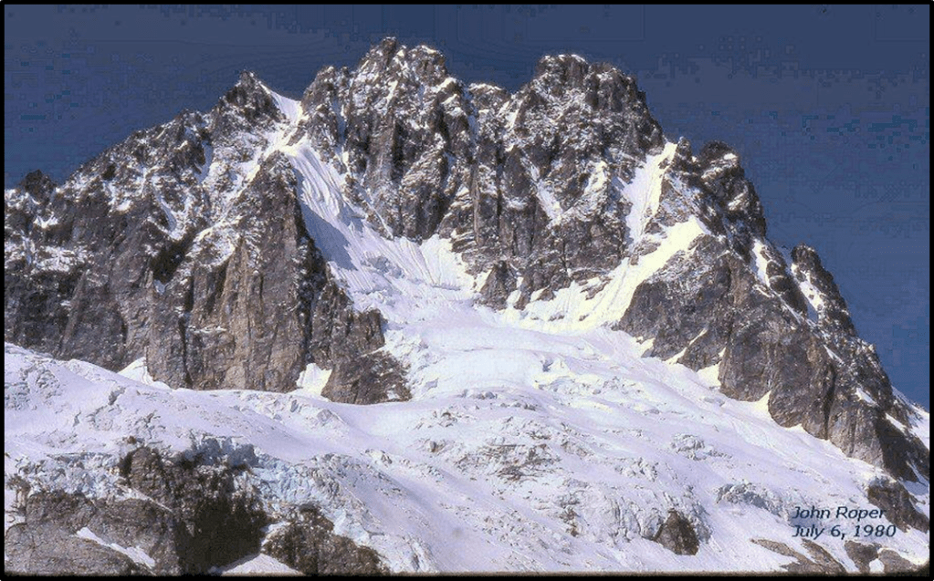
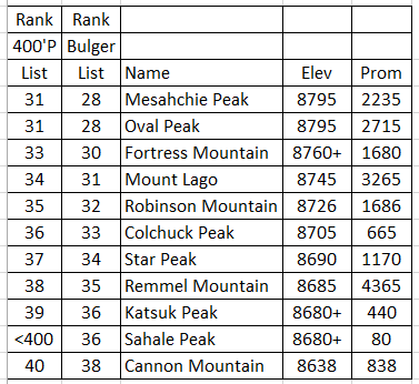
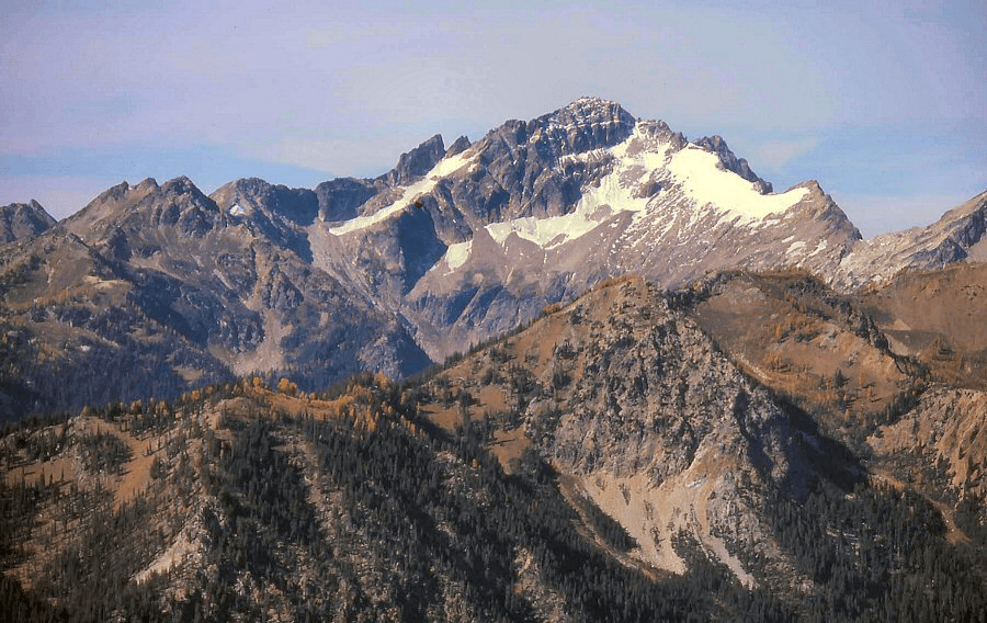
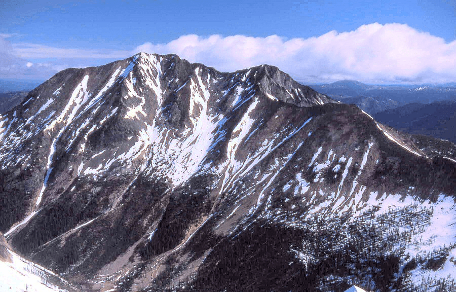
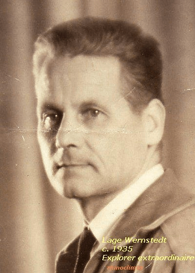
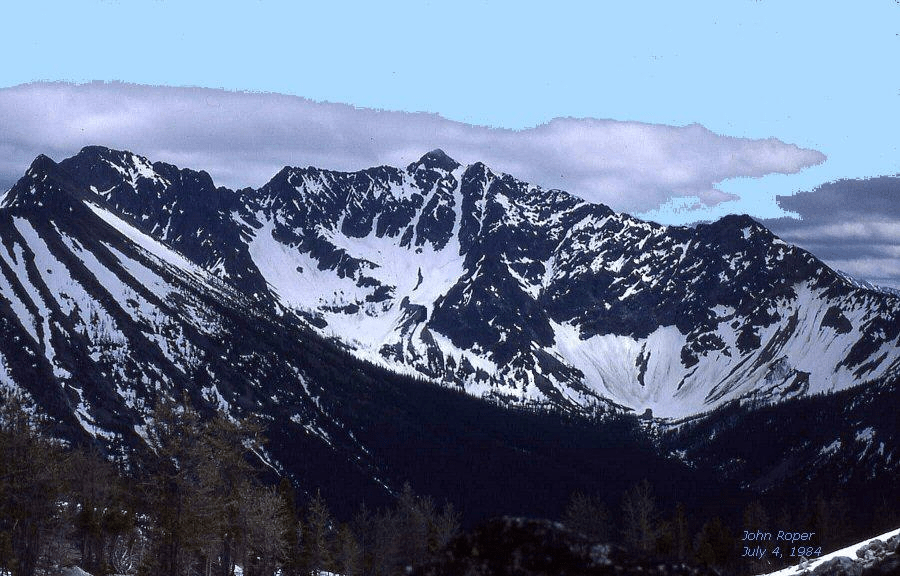
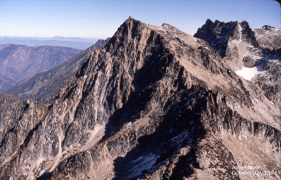
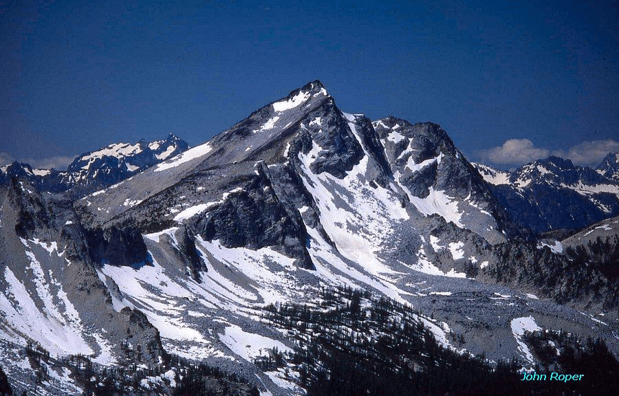
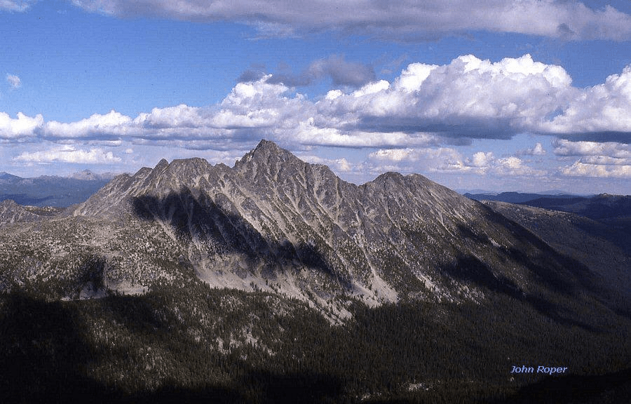
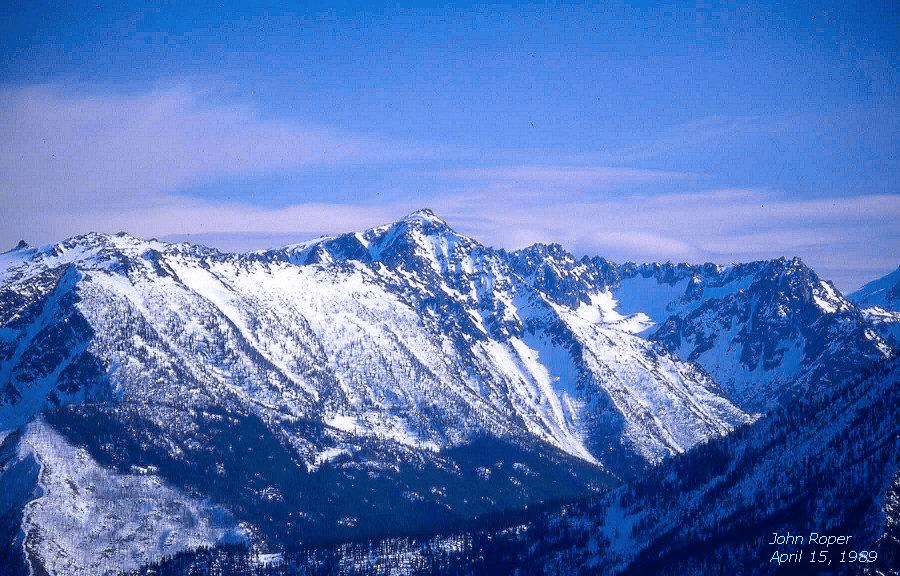
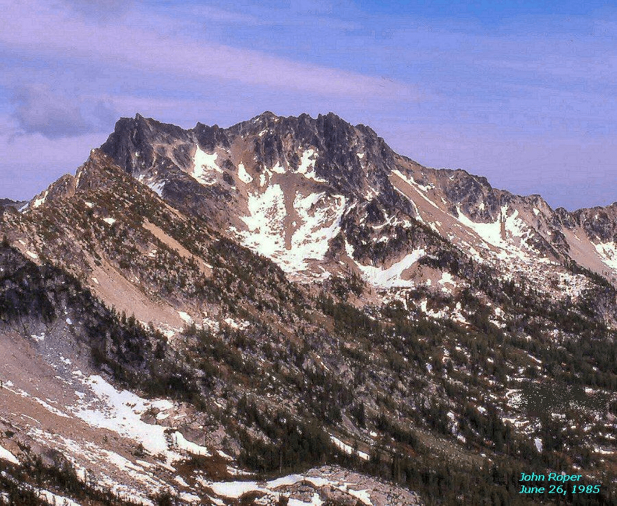
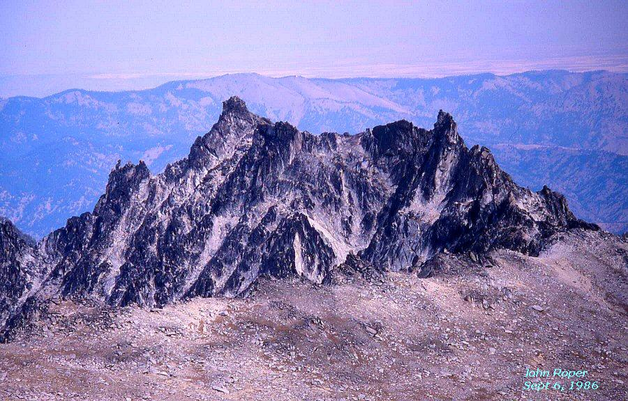
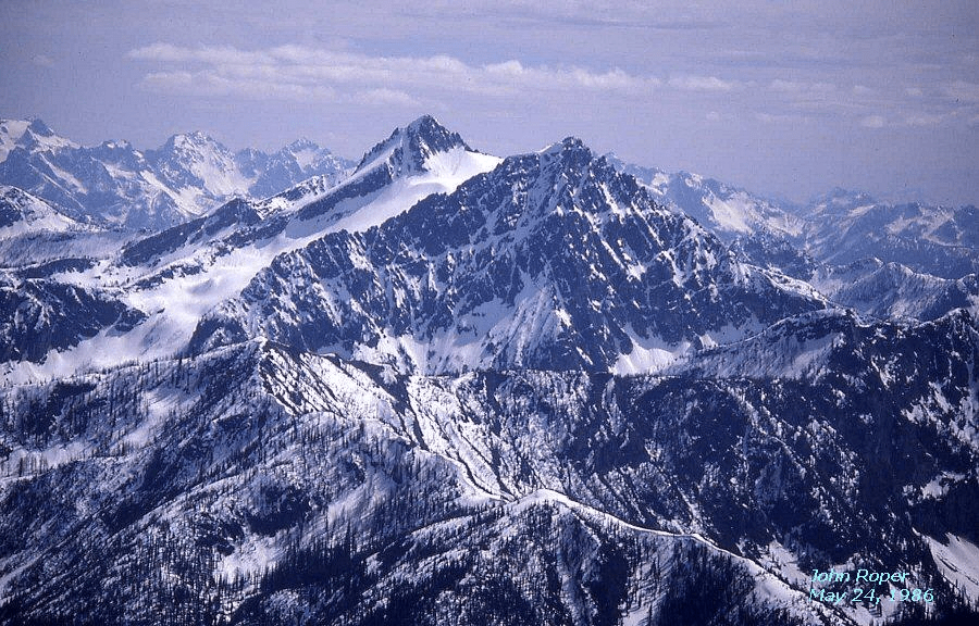
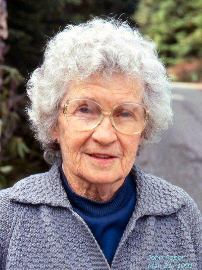
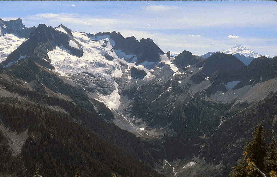
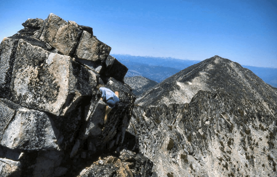
OVAL PEAK 8795′ / P2715from SW, on Gray Peak MapFORTRESS MOUNTAIN 8760+ / P1680from SE. Fortress “grew” more than any other peak in the Top 100 on the updating of the 15-minute to 7.5-minute maps. It leapt 86 feet skyward, from 8674′ on the 1944/63 15-minute USGS Holden quad (the map the Bulgers used), to 8760+ on the “new” 1988 7.5-minute USGS Suiattle Pass quad.MOUNT LAGO 8745′ / P3265from BlackcapLage Wernstedt, possibly on the first ascent of Mount Lago, his namesake, about 1926. This photo is from the Dottie (Adele) Wernstedt Grahamand Doris Burn collection. Lage named Dot Mountain and Lake Doris for his wife and daughter.Lage Wernstedt (1878-1959: 81 years), photo taken about 1935. Swedish-born Lage (pronounced “Loggy”) was a North Cascades explorer extraordinaire (largely in the Methow), surveyor, climber, photographer, unique name-bestower, mechanical engineer, map-maker, Yale-trained forester, inventor of aerial stereoscopic photography to produce contour maps, and an originator of the smoke-jumpers. All of this was discovered by mountain scholar and historian, Harry Majors, and published in his 1975 classic, “Exploring Washington,” now unfortunately out of print, where Harry documents 4769! fascinating historic facts, most previously unknown, about all of Washington, each pinpointed precisely by numbers on 27 different 60-minute, one-degree maps (equal to four pages in DeLorme) that cover the entire state. Harry postulates that Lage holds the record for “the most first ascents of major peaks in the North Cascades at 77.” Lage Wernstedt’s name has been associated by his photographs in 1925 and 1926 with actual (or near) first ascents of up to 13 Top 100 peaks: Lago, Osceola, Carru?, Blackcap, Lost, West Craggy, Big Craggy?, Ptarmigan (HMM, not FB), Lake, Logan, Black, Azurite?, Silver Star.ROBINSON MOUNTAIN 8726′ / P1686from NW, near Wildcat showing Crusoe Couloir that Reed Tindall and I did as a new route June 16, 1985. We descended from the pass on the right, down across the snowy basin, to the base of the snow couloir that shoots up to just right of the summit. Just a matter of time before the skiers find it, but it was dangerously icy in June. (Sky Sjue and Phil Fortier sniffed out this route on 6/15/05.)COLCHUCK PEAK 8705′ / P665from Argonaut side. Dragontail on (R).STAR PEAK 8690′ / P1170from East, on Hoodoo. Note rock glacier.REMMEL MOUNTAIN 8685′ / P4365from NW, on Amos Peak’ (aka North Andrews). Andrews Creek on right. Jerry Baillie finished the Bulger List here in 2002, two months after breaking his ankle.MOUNT HOLYOKE/KATSUK PEAK 8680+ / P440from SE, atop Arriva. (L) to (R): Ragged End (Cosho), Gendarmes (Kimtah) , Mount Holyoke (Katsuk), Panther (Mesahchie).Joe Vance finished the Bulger Big Boys on Katsuk in 1988.MapNorth Cascades Peak Baggers (NCPB), Chris Roperand John Roper on first ascent of Mount Holyoke(Chris’ alma mater), August 22, 1968.SAHALE PEAK 8680+ / P80 above Doubtful LakeSAHALE PEAK 8680+ / P80the little point on the right, and on the Bulger List by virtue of being a high non-volcanic summit with a map name. Forbidden Peak (L), Boston Peak (C). From Hidden Lake with two of my favorite people, son Aaron, and Gary Mellom, my long-time Newhalem climbing buddy.The locals call it a peak, the map calls it a mountain. CANNON MOUNTAIN 8638′ / P838from NNWMOUNT CUSTER 8630′ / P1230from Redoubt. Rahm and Devils Tongue poking up over right ridge. Depot Creek below.
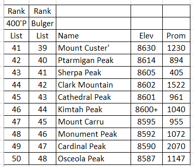
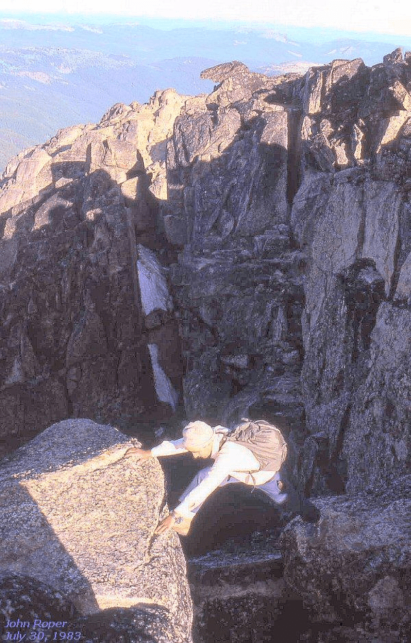
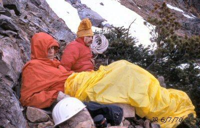
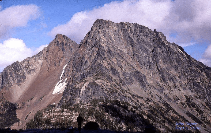
PTARMIGAN PEAK 8614′ / P894. From SE on Lost. This was the final Bulger Big Boy for Bruce Gibbs (second completer) in 1986, and Johnny Jeans in 1997. Johnny’s claim to fame is that he climbed every one of the Top 100 after reaching the age of 50.SHERPA PEAK 8605′ / P405from SW. Note the intriguing balanced rock (The Sherpa’s Load’) on the right summit. Luckily, it is just a bit lower than the left summit.CLARK MOUNTAIN 8602′ / P1522from NorthCATHEDRAL PEAK 8601′ / P961. East face. It was Cathedral Peak that turned me on to the Bulger List in 1983. Russ had been proselytizing me for 3 years, but I had resisted. I was a North Cascades chauvinist who scoffed at the silly thought of chasing after the “high rollers” in the Pasayten, but another rained-out trip two days into an attempted Picket Traverse made us look to sunny eastern Washington to make use of the remaining vacation. A guy could get hooked on this place, and did.CATHEDRAL PEAKfrom BaldRon Aronoff makes the long, thought-provoking, step-across move near Cathedral’s top.GENDARMES/KIMTAH PEAK 8600+ / P1040from NE. Cosho/Ragged End’ is the dome above the central Kimtah Glacier.Morning after a miserable night’s bivouac, shaking the cobwebs outbefore the FA of Gendarmes/Kimtah Peak on June 7, 1970 with Jerry Swanson.MOUNT CARRU 8595′ / P955from Blackcap. Silas Wild and I had one of the great sitting glissades in the Cascades here, zooming 2500 vertical feet from the summit to the bottom of the slithering couloir in 18 minutes.
MONUMENT PEAK 8592 / P1072from North. Russ Kroeker celebrates life on Blackcap pinnacle.Fred Beckey on the First Ascent of Monument Peak, September 26, 1978. Fred had heard rumor that there were a bunch of fanatics going around the state, trying to climb the highest peaks, and he figured this was one of them, and that we ought to investigate before they got there. The Bulgers peaked out on Monument the very next spring, May 26, 1979. A year after this I met Russ Kroeker and learned of their mission. Fred’s other first ascents on the Big Boy List include these seven: Lincoln, Forbidden, Enchantment, SE Mox, NW Mox, Golden Horn, and Big Snagtooth.CARDINAL PEAK 8590′ / P2070from NW, Saska sideOSCEOLA PEAK 8587 / P1147. Russ Kroeker, Silas Wild, and John Roper did a new route on this peak up the slanting snow “Oscy Couloir” on July 5, 1984, shown here from the NE.
Peaks 51-60
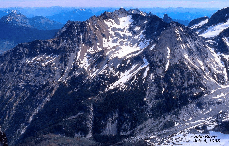
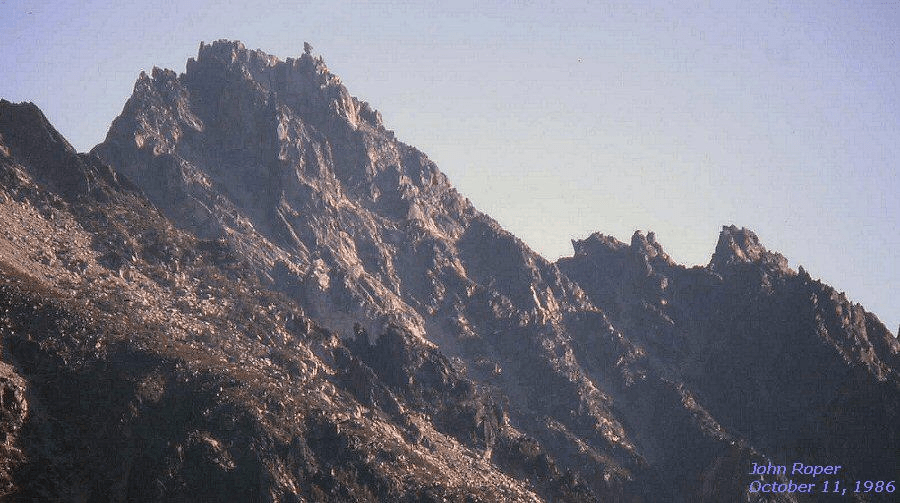
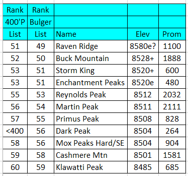
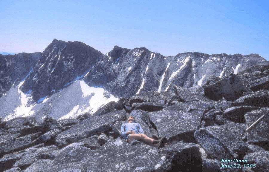
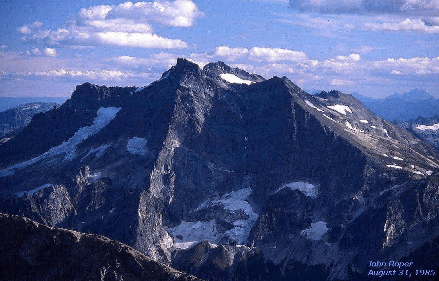
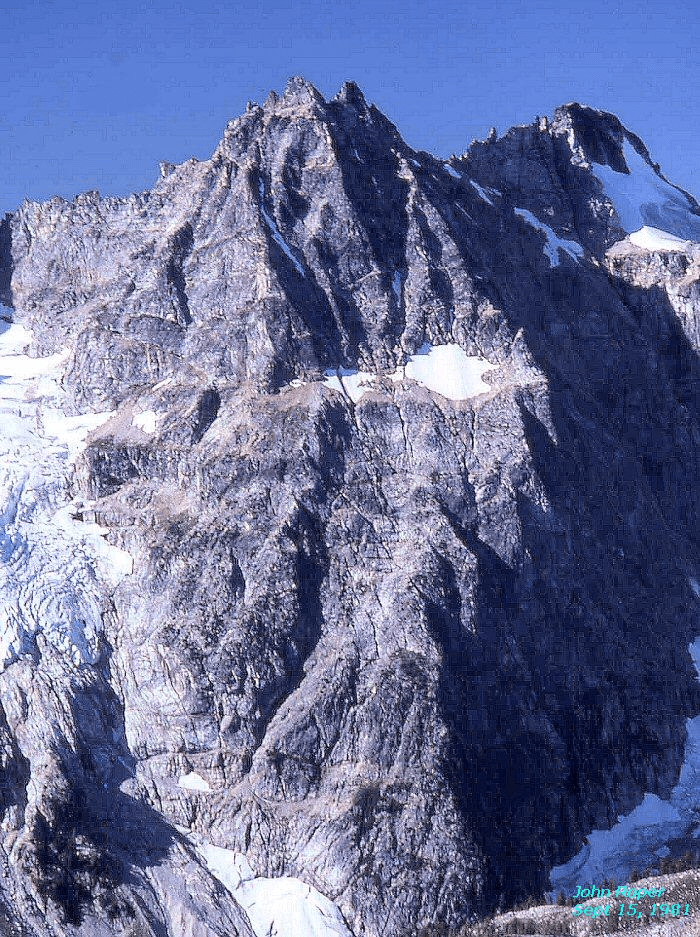
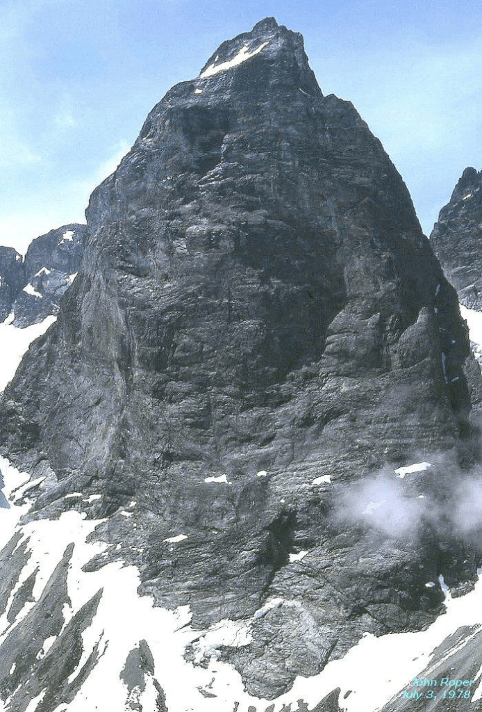
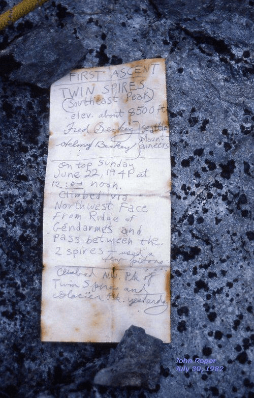
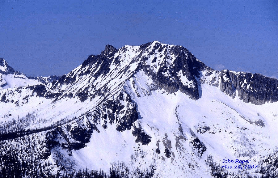
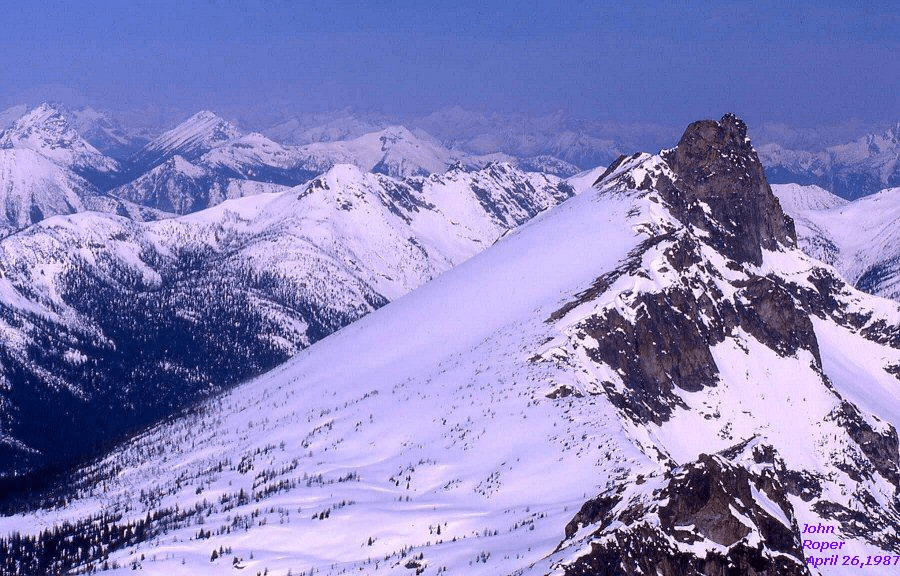
e: errors on current 7.5-minute USGS maps. See following discussion.RAVEN RIDGE (LIBBY PEAK) 8580′ / P1100 This view from Hoodoo Peak suggests that the 8572′ summit on the left is higher than the 8580′ summit on the far right that the map recommends. This was noted in 1985. Don Duncan, in a report to the Mountaineers, measured and estimated that the east (L) “8572” summit was 17-feet higher than the 8580 Libby (R) summit. On May 28, 2004, Jim Brisbine confirmed to himself by pocket transit that the 8572′ point on Raven Ridge (“Corax Peak” to some, after the genus name for raven) was higher than 8580 Libby (after the lake below). Better do them both nowadays. Map.BUCK MOUNTAIN 8528+ / P1888from NW. The highest point is a rounded 8520+/actually 8528+ summit, hidden in this photo by the slightly lower sharp 8528-foot Buck horn, topping the elegant North Arete. Our 2004 finisher, Dave Stephens, completed the Bulger List here.STORM KING 8520+ / P600from NE. 3500 vertical feet on entertainment from the bottom. This is where Don Goodman finished the Bulger List in 1998.ENCHANTMENT PEAKS 8520+ / P480from SW on Dragontail.The highest point on Enchantment Peaks is the NE summit, the left rock knob here, shown as a precise “8520” on the 1961 15-minute USGS Mount Stuart quad that the original Bulgers used. This map showed the SW crags (on right) as three separate 8480+ contours. When the 1989 7.5-minute USGS Enchantment Lakes quad came out it mistakenly drew the SW crags as two 8480+ contours and a single 8520+ contour, and the NE (true) summit as the 8480+ contour. REYNOLDS PEAK 8512′ / P2032from NNE on AbernathyMARTIN PEAK 8511 / P2111from West, at base of Mary Green Glacier camp on BonanzaIda Zacher Darr soloed the first ascent of Martin in July 1936 when she was 24 years old. This is the year she married Everett Darr. They returned in 1940 to make the FAs of Tupshin and Devore, and several other peaks in the area. This photo was taken at her home in Oregon in 1991 at the age of 79 (b. 1912).PRIMUS PEAK 8508′ / P828on left from NW, near IsolationDARK PEAK 8504′ / P264from North. Dark is a Bulger peak with less than 400 feet of prominence, but an interesting, remote, and recommended adventure, approaching via Swamp Creek below. SW Bonanza is off to the left. Glacier Peak on right. Dark was Silas Wild’s last Big Boy in 1987.MOX PEAKS, SE (aka Hard Mox, SE TWIN SPIRE) 8504′ / P904. East Face, from Perry Creek. This is the greatest face in the North Cascades with 2500 vertical feet of relief, and still yet unclimbed in 2004. (Update: this route was finally finished–to right of central shadow–on the FA of this ESE summit of Mox on 9/13/2008 by Rolf Larson and Eric Wehrly.) Hard Mox was the final Bulger peak for Bob Tillotson, followed by Bette Felton, the first woman to complete, two weeks later in 1986.
Winter aerial photos of the Moxs by John Scurlock: 123
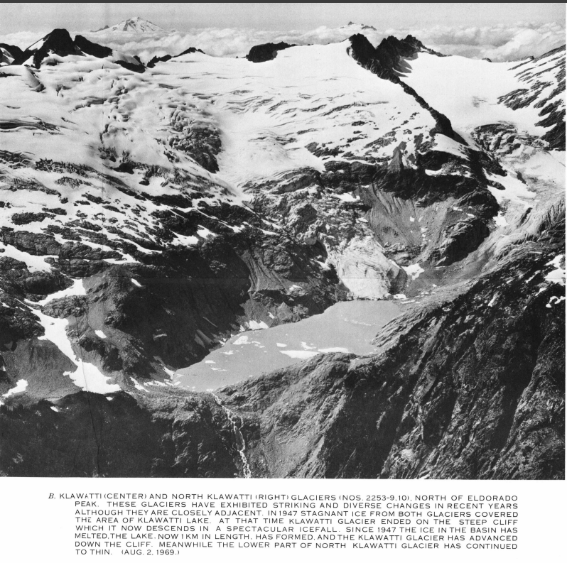
Fred and Helmy Beckeys’ original June 22, 1941 first ascent register,where it should be, on the top of the mountain they climbed.CASHMERE MOUNTAIN 8501′ / P1581from NorthKLAWATTI PEAK 8485′ / P685from the Klawatti Glacier. This beauty is totally surrounded by ice. Glaciologist Dick Hubley was so impressed with the icy white blanket here that he applied the Chinook name “Kahloke” for “swan” to this glacier. Austin Post told me he “polished” Kahloke a bit to the “more unique and attractive Klawatti.”
Winter aerial photo of Klawatti by John Scurlock: 1. And here is a shot by Austin Post.
Peaks 61-70
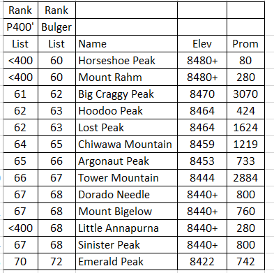
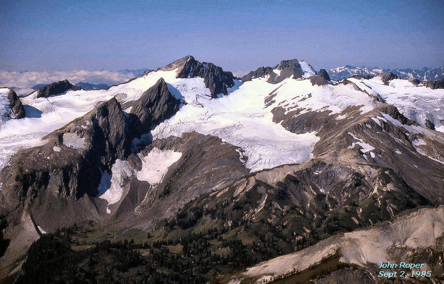
<400 means this peak has less than 400-feet of prominence. Peaks with the same elevation are given the same rank.HORSESHOE PEAK 8480+ / P80. Sahale Peak is on the left, Mount Buckner on the right, connected by Ripsaw Ridge. The original Horseshoe Peak name was applied by miners to the horseshoe-shaped summit (with the V notch) in the middle of Ripsaw Ridge above Horseshoe Basin, as shown on the 1962 Mt. Baker National Forest map. When the 1963 USGS Cascade Pass quad came out a confused office cartographer had moved the “Horseshoe Peak” words on the map over to a non-descript rotten crag just west of Buckner. This transposition led to the inclusion of this peak on the Bulger List as it became a named summit with sufficient elevation, even though it has only 80 feet of prominence. Many a climber has grumbled about this peculiarity, especially on this chossy pinnacle. The case for the desirability of a one-rule Top 100 List (400-foot prominence only) is rested. HORSESHOE PEAK 8480+ / P80. The original Forest Service maps had the Horseshoe Peak name on a V-notched, horseshoe-shaped summit in the middle of Ripsaw Ridge. The 1963 USGS Cascade Pass quad moved the label to this crag. Bulgers Russ Kroeker, Bruce Gibbs, Bette Felton, and Mary Jo Gibbs made its FA on July 13, 1980. Lick of Flame is immediately right of it.
Click here for a good close-up shot of “Bulger Horseshoe” by Paul Klenke.
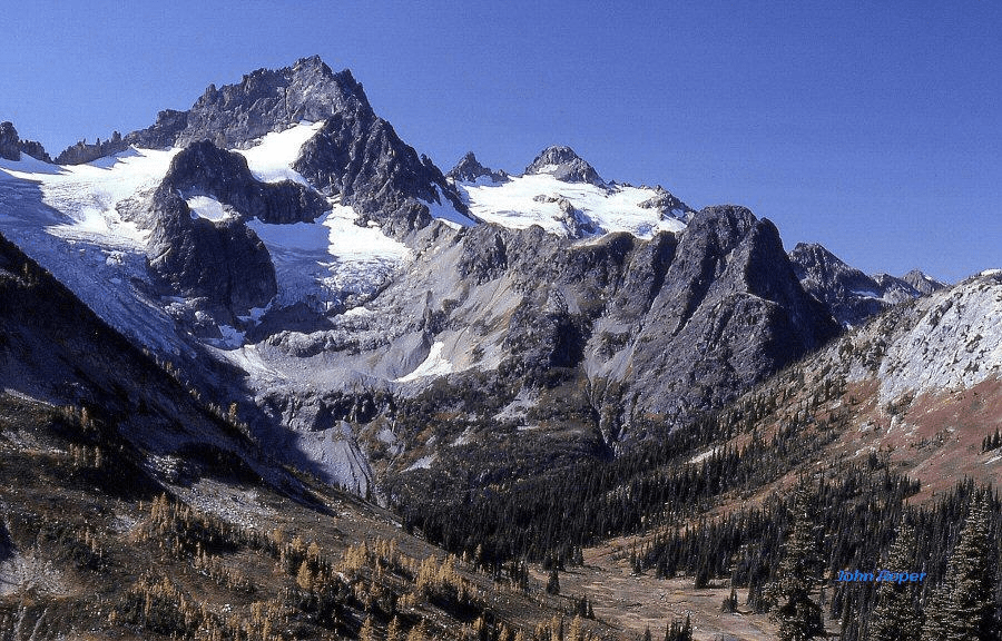
MOUNT RAHM 8480+ / P280from the North on Silvertip-Rideout ridge in Canada, looking up Maselpanik Creek. Rahm is the left snow-topped summit. The map shows its barely lower right rocky top as 8480+, but the “8478” left snow summit is higher. (L) to (R) are Devils Tongue, Rahms Horn’ (aka McNaught Peak’), Rahm, Ag Peak’, Spickard (highest central), and Custer.BIG CRAGGY PEAK 8470′ / P3070from West CraggyHOODOO PEAK 8464′ / P424. Silas Wild on traverse from Libby Peak’.LOST PEAK 8464′ / P1624from NW. This was my final Bulger Big Boy on May 24, 1987, and Mike “Buffalo” Bialos finished here in 1997. The Buff never admitted to wanting to do the Bulger List, but finally made it by continuing each year to climb the highest peak in Washington that he had not yet climbed. CHIWAWA MOUNTAIN 8459′ / P1219from SEARGONAUT PEAK 8453′ / P733from NWTOWER MOUNTAIN 8444′ / P2884, Western Cwm of Tower in April.DORADO NEEDLE 8440+ / P800, The snowy right pyramid, Eldordo Peak on left. Dorado Needle was the last Top 100 peak for John Plimpton in 1995, and Mike Torok in 2002.DORADO NEEDLE 8440+from SW on The TriadMOUNT BIGELOW 8440+ / P760from NW on Seance Peak. Glaciologist and aerial photographer Austin Post has noted that this peak’s north-side, rock-covered glacier is the farthest east glacial ice in the Cascades. He calls it Eacas Glacier, for Ea(st)cas(cade).LITTLE ANNAPURNA 8440+ / P280from NE, near Prusik Pass, across Perfection LakeSINISTER PEAK 8440+ / P800from NW, above Chickamin Glacier. On October 4, 1980, Russ Kroeker became the first person to finish the Bulger Top 100 peaks. He did it on Sinister.
Winter aerial photo of Sinister by John Scurlock: 1
EMERALD PEAK 8422′ / P742on right, from SW on Saska. Bearcat Peak (L) was one of the Top 200 Peaks in Washington, but that’s a whole ‘nother ten years out of your life, and another USGS 15-minute to 7.5 minute alteration of the data.
Peaks 71-80
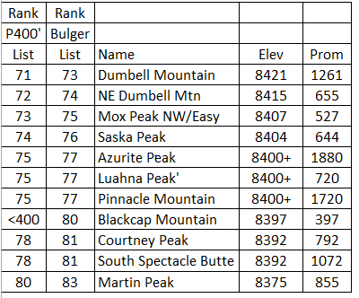
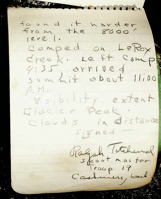
<400 means peak does not have 400 feet of clean prominence. Peaks with the same elevation are ranked the same.DUMBELL MOUNTAIN 8421′ / P1261from NW on Martin. The high point is third from left of the four crown points. Railroad Creek below. Big Creek on left.NE DUMBELL MOUNTAIN’ 8415′ / P655from SE. NE Dumbell is the sharpish peak right of the lowest central saddle. It is not green, and it is not wood. There was a recent thought that a 8400+ northern subsummit (the point right of NE Dumbell 8415 in photo) was higher . To settle this, on October 10, 2004, Fay Pullen took a sighting clinometer, “a quality surveying instrument” to 8415 and determined that it was “higher by about 1 degree” than the north point. Other summits in this photo are Genius Peak’ on left (a Top 200 summit), and Dumbell Mountain, left center. Bonanza is being gobbled by a lenticular cloud on right.Bob Tillotson holds the July 4, 1937 first ascent register left by a lost scoutmaster on NE Dumbell. He thought he had made the FA on Mount Fernow, which is across the Big Creek valley 2.6 miles away.Ralph Titchenal’s FA register on NE Dumbell.Mike Torok photoMOX PEAKS (NW) 8407′ / P527from South on Ridge of Gendarmes. Col of the Wild lower right.SASKA PEAK 8404′ / P644from NE. Saska on far right. (L) to (R) are Cardinal, Bearcat, Emerald, and Saska, looking up Emerald Park Creek.Saska from EmeraldAZURITE PEAK 8400+ / P1880
Winter aerial photo of Azurite by John Scurlock. 1
LUAHNA PEAK 8400+ / P720 left center, from North. Chalangin Peak right center. Richardson Glacier (L), Pilz Glacier (C), Butterfly Glacier (R).PINNACLE MOUNTAIN 8400+ / P1720, From SW, the rounded right summit.BLACKCAP MOUNTAIN 8397 / P397. Left Center from NW in Eureka Creek. Monument Peak on right.Blackcap from EastCOURTNEY PEAK 8392′ / P792from NW on Gray. This is now an official name honoring Stehekin horse packer Ray Courtney, but it does not show on the 1968 USGS Oval Peak quad.SOUTH SPECTACLE BUTTE 8392′ / P1072from West at Ice Lakes
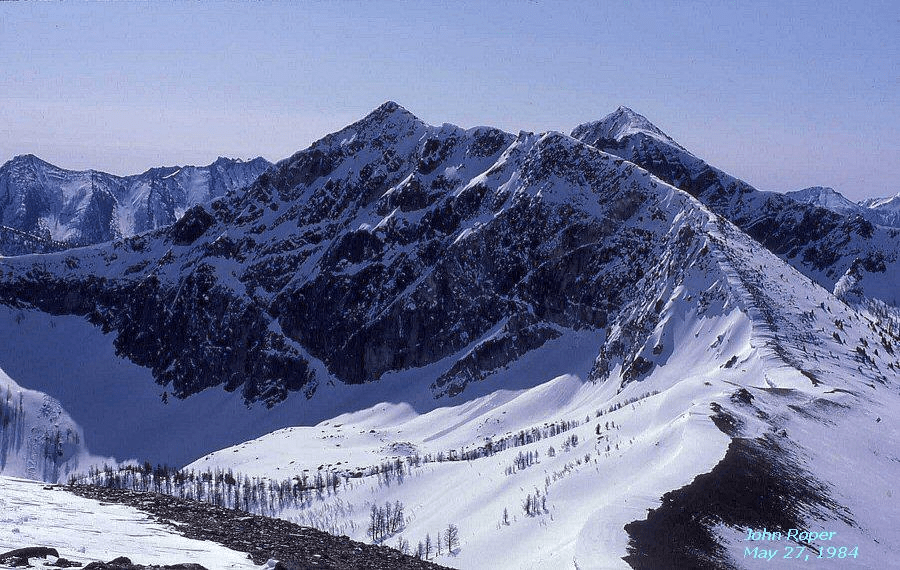
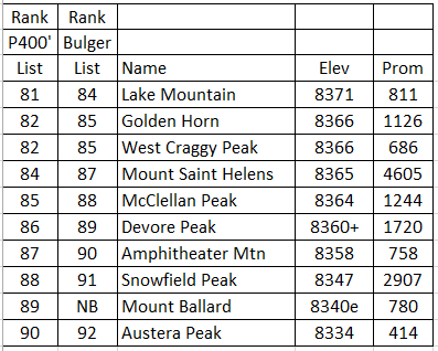
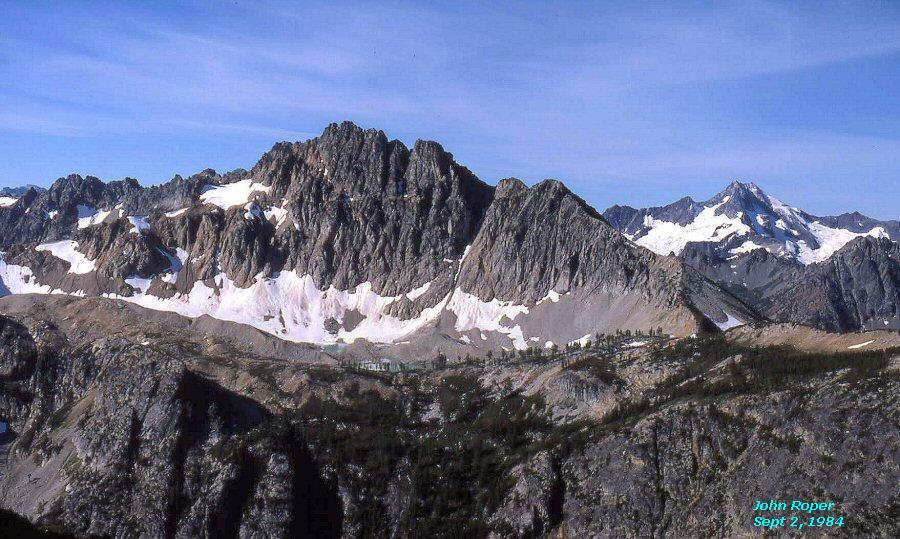
MARTIN PEAK 8375′ / P855. The Chelan-Sawtooth Martin from North on Cheops Peak,NB/e: Ballard is not on Bulger List because of a map error. Ballard elevation is an estimate. Peaks with the same elevation are given the same rank.LAKE MOUNTAIN 8371′ / P811from NE, on way to Lost. Lake of the Woods lies in left basin.GOLDEN HORN 8366′ / P1126from Tower. Gabriel and Elija on left.
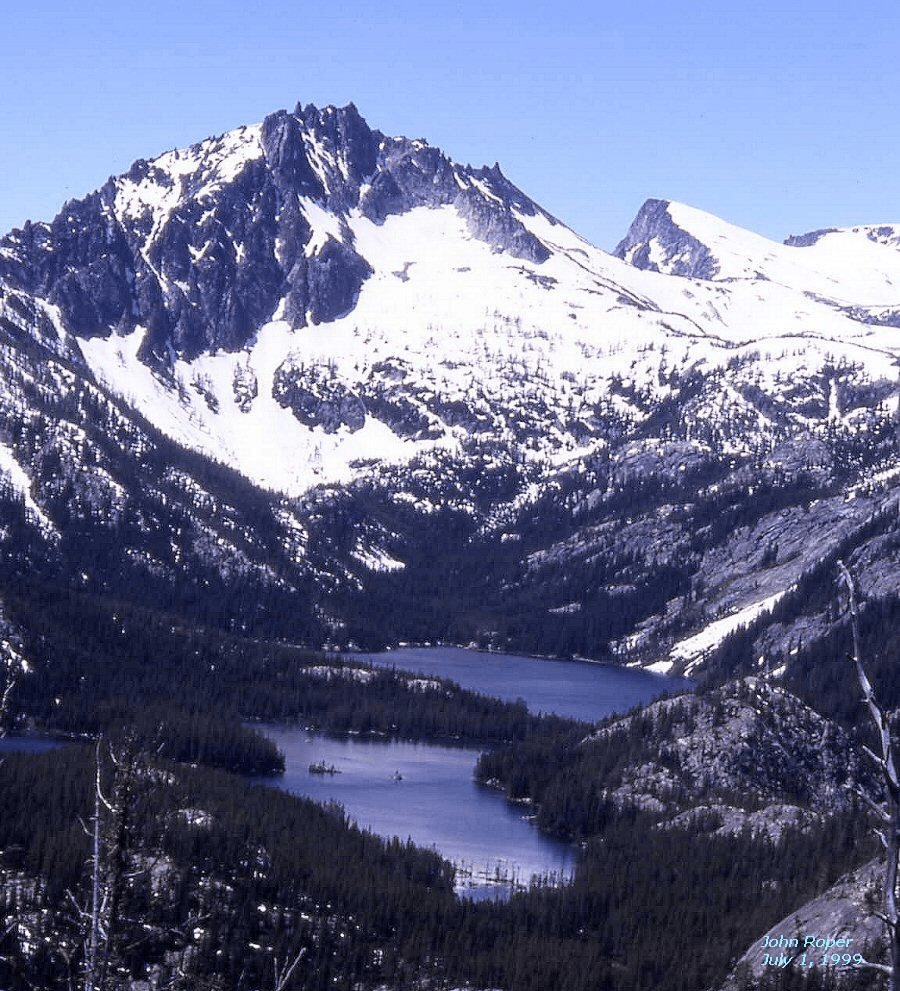
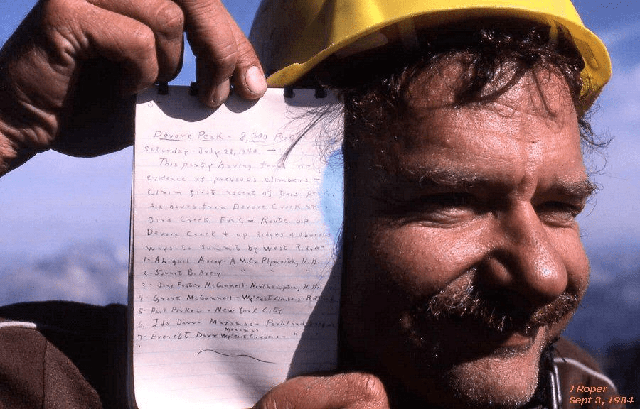
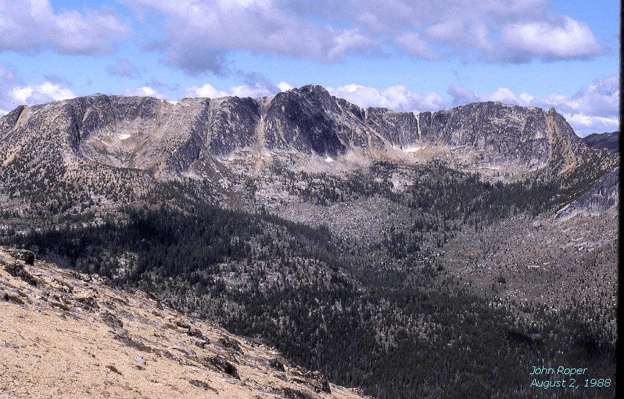
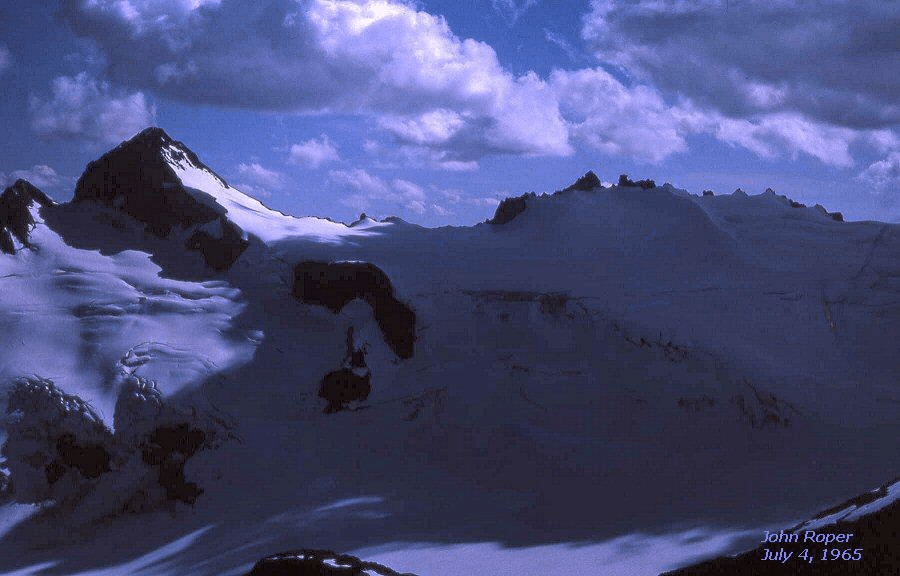
WEST CRAGGY 8366′ / P686from NE on North CraggyMOUNT SAINT HELENS 8365′ / P4605. Post-eruptive Mount Saint Helens from SW, Goat Marsh LakeMcCLELLAN PEAK 8364′ / P1244from NE on Wedge Mountain. Snow Lakes in foreground. Little Annapurna (R).DEVORE PEAK 8360+ / P1720from NE on Tupshin. Bird Lakes at base. Bonanza to right.Russ Kroeker displays the historic Devore Peak FA register from Saturday, July 28, 1940.AMPHITHEATER MOUNTAIN 8358′ / P758from East on Apex MountainSNOWFIELD PEAK 8347′ / P2907from NE, on Colonial. Neve Glacier dominates the scene. In retrospect, this was my first Top 100 Peak, done on July 4, 1965 with medical school classmate, Joel Wilson (Jay) Baker, Jr. Snowfield was the first summit that Gary Mellom and I ever climbed together (September 3, 1966), and it was also the first peak that Russ Kroeker and I teamed up on (June 7, 1980). Russ introduced me to the Top 100 List here, and that year became the first person to finish all 100 Big Boys, six years before the second to complete. Russ and I came up the ridge between Ladder Creek and the Skagit River from Newhalem, climbed Snowfield, and exited down Neve Creek to Thunder River (Creek). Not a lot of traffic on those routes in those days.
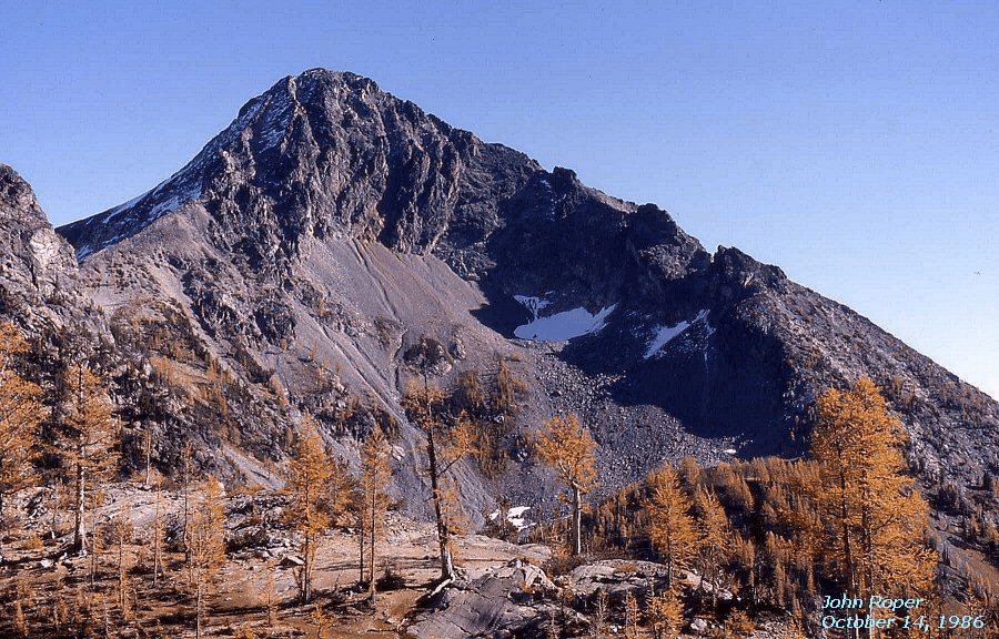
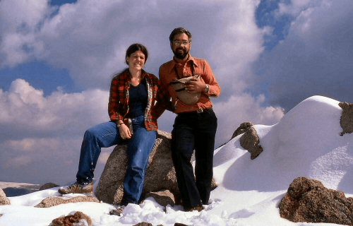
MOUNT BALLARD 8340′ / P780from EastThe north summit of Ballard shown here is surveyed at 8301 feet. This photo was taken from the clearly higher southern “8280+” contour (per map) summit, so the true summit of Ballard is now estimated at about 8340 feet, awaiting an accurate measurement. I was going to call it 8350, but that would rank it higher than Snowfield, and I wasn’t going to do that to a Backyard peak,AUSTERA PEAK 8334′ / P414on left from South on The Smokestack’ with John Burroughs. Primus Peak center and Jack behind.m: elevation is from metric mapWINDY PEAK 8333′ / P1771 on (R) from ENE. Don Beavon’s last Bulger Big Boy in 2003.Karen and John Roper on Windy Peak, September 21, 1986. This was Karen’s first Top 100. She still has only 99 to go.Thanks, dear, for this birthday website, and another excuseto paw through my slides.COSHO PEAK (RAGGED END) 8332′ / P492from WNW on Red Mountain
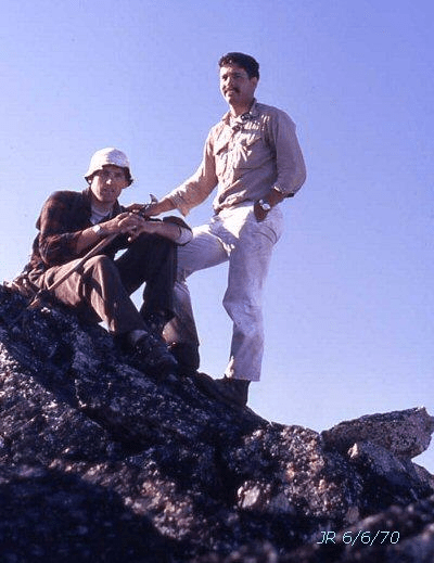
Jerry Swa
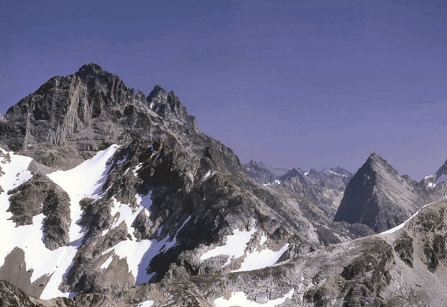
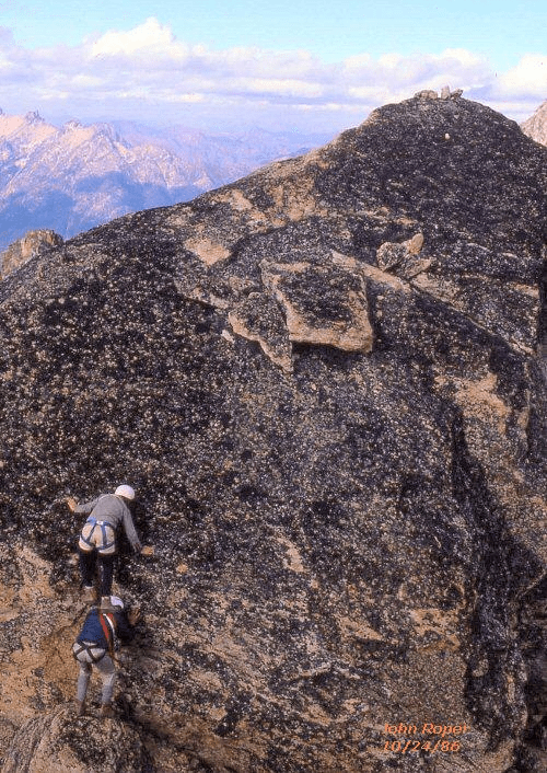
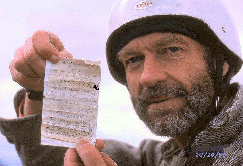
Jerry Swanson and John Roper on FA of Ragged End, June 6, 1970. BIG SNAGTOOTH 8330+ / P570is the highest of the three left crags, then comes Willow, Cedar, Decayed, Red, Milk, and Dog Tooth from NE at Silver Star-Silver Moon gap.BIG SNAGTOOTH. Shoulder stand move, Joe Vance on Don Avriett’s back, October 24, 1986.Joe Vance displays the September 29, 1946 FA register of Chuck Welsh, Fred Beckey, and Jerry O’Neil.
We came by only 40 years later. Joe has the distinction spreading out the quest for the Top 100 over the greatest number of years, taking from 1947 to 1988–41 years–to complete, soloing 35 Big Boys. “Reminiscing I would say that Cathedral, Argonaut and Forbidden were the solo climbs which made me most uncomfortable. Nervousness on the latter was heightened on reading in the register that the last party to summit Forbidden included Warren Spickard who had died a few weeks earlier [8/20/1961] on NW Mox Peak.”
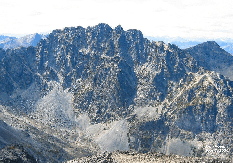
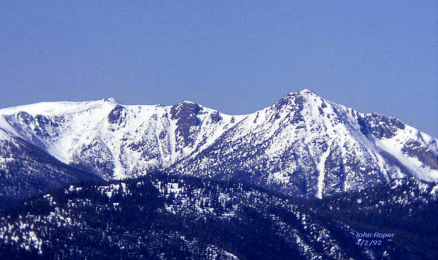
MOUNT FORMIDABLE 8325′ / P1885from NE. Peggy Goldman’s last Big Boy in 2003. On the hike out, Jim Quade tore a plantaris (calf) tendon and got a free helicopter ride out. Pika Peak’ (L), Ome Dome’ (Center).
Winter aerial photos of Formidable by John Scurlock: 12345
ABERNATHY PEAK 8321′ / P801from NE on Big KangarooCOONEY (SWITCHBACK) MOUNTAIN 8321′ / P441from NETUPSHIN PEAK 8320+ / P1080(L) from West on Sisi Ridge. White Goat Mountain (R).FLORA MOUNTAIN 8320′ / P1800from NW. This is the lowest Bulger peak. Chris Weber’s last Bulger Top 100, in memory.LUNA PEAK 8311′ / P3120from SE on Pumpkin Mountain. McMillan Creek (L), Big Beaver Creek (R). Don Goodman became the second person to finish the Top 100 by P500 and the third person to finish the Top 100 by P400 on Luna, September 14, 2007.
CASTLE PEAK 8306′ / P3226from East near Mount Winthrop. Custer, Hozomeen, and Rahm (L). Full Moon Rising (R). Note the huge prominence on this peak, ranking it 20th in this category of the Top 100 peaks.


